IMAGES TAKEN NEAR TO
Station Close, RIPON, HG4 1JF
Introduction
This page details the photographs taken nearby to Station Close, HG4 1JF by members of the Geograph project.
The Geograph project started in 2005 with the aim of publishing, organising and preserving representative images for every square kilometre of Great Britain, Ireland and the Isle of Man.

There are currently over 7.5m images from over14,400 individuals and you can help contribute to the project by visiting https://www.geograph.org.uk
Image Map (Loading...)


Getting Data...Please wait
Leaflet Map data © OpenStreetMap
Images are licensed for reuse under creativecommons.org/licenses/by-sa/2.0
Notes
- Clicking on the map will re-center to the selected point.
- The higher the marker number, the further away the image location is from the centre of the postcode.
Image Listing (67 Images Found)
Images are licensed for reuse under creativecommons.org/licenses/by-sa/2.0
Image
Details
Distance
1
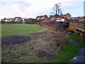
Albion Varnish Works
part of the former Varnish Works at Ure Bank.
Image: © David Rogers
Taken: 11 May 2013
0.03 miles
2
Ripon, Hutton Bank
Older brick building - cutmark/benchmark between gatepost and drainpipe
Image: © Mel Towler
Taken: 3 May 2021
0.05 miles
3
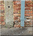
Ripon, Hutton Bank
Benchmark, damaged, between concrete gatepost and drainpipe
Image: © Mel Towler
Taken: 3 May 2021
0.05 miles
4
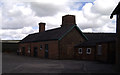
Old Railway Station, Ripon
The old railway station stood a mile north of the city centre and welcomed its first train on May 31st 1848. The station remained open for passenger traffic until 1967 when the line north and south was closed. Now there are calls for a new line to link Ripon with Harrogate. The station buildings were converted for residential use.
Photographs of the station before and after closure can be seen at http://www.disused-stations.org.uk/r/ripon/index.shtml together with the history of the railway that used to run through here.
Image: © Gordon Hatton
Taken: 30 Dec 2007
0.06 miles
5
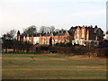
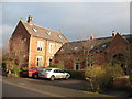
Ure Bank Terrace
A row of Victorian properties overlooking the River Ure on the north side of the city. Built after the arrival of the railway, with the station being only a five minute walk away. Properties on the north side of Ripon run the risk of subsidence due to underground gypsum dissolution. A new property just a few yards beyond the last house in this photo [with the tower] had to be abandoned in 1997 when a 10m diameter, 5 metre deep hole appeared in the front garden and swallowed the garage.
Image: © Gordon Hatton
Taken: 30 Dec 2007
0.08 miles
6
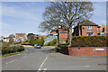
Ure Bank junction with Station Drive
The blue plaque on the wall says that this was the site of Ripon's railway station.
Image: © Mark Anderson
Taken: 4 Apr 2021
0.08 miles
7
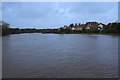
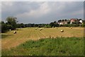
River Ure Floodplain at Ure Bank on 06/12/2015
Image: © David Rogers
Taken: 6 Dec 2015
0.09 miles
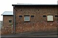
8
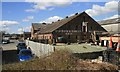
Ure Bank Maltings
The main rail line north from Leeds ran past this spot until finally closing in 1969. The Maltings sited just North of the old Ripon Station was served by a short branch off the main track. Image
Image: © David Rogers
Taken: 17 Apr 2008
0.09 miles
9
Ure Bank
From the same spot as Image, looking to the right. A brick arch beneath the stonework on the right was presumably over a drainage channel.
Image: © Derek Harper
Taken: 2 Jan 2013
0.10 miles
10
Ure Bank, Ripon
This is the site of one of Ripon's former race courses where the first meeting took place in 1837.
Image: © David Rogers
Taken: 13 Jul 2013
0.11 miles