IMAGES TAKEN NEAR TO
Magdalens Close, RIPON, HG4 1HH
Introduction
This page details the photographs taken nearby to Magdalens Close, HG4 1HH by members of the Geograph project.
The Geograph project started in 2005 with the aim of publishing, organising and preserving representative images for every square kilometre of Great Britain, Ireland and the Isle of Man.

There are currently over 7.5m images from over14,400 individuals and you can help contribute to the project by visiting https://www.geograph.org.uk
Image Map (Loading...)


Getting Data...Please wait
Leaflet Map data © OpenStreetMap
Images are licensed for reuse under creativecommons.org/licenses/by-sa/2.0
Notes
- Clicking on the map will re-center to the selected point.
- The higher the marker number, the further away the image location is from the centre of the postcode.
Image Listing (126 Images Found)
Images are licensed for reuse under creativecommons.org/licenses/by-sa/2.0
Image
Details
Distance
1
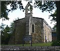
St Mary Magdalen, Ripon
A 12th. century leper chapel.
Image: © David P Howard
Taken: 11 Jul 2006
0.02 miles
2
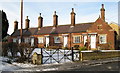
Magdalen's Almshouses
Beside Magdalen's Road.
Image: © David Rogers
Taken: 4 Jan 2010
0.03 miles
3
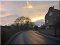
Magdalen's Road, Ripon
With sunset approaching. The road curves past an end terrace with a Dutch gable and the junction with Magdalen's Close.
Image: © Derek Harper
Taken: 2 Jan 2013
0.03 miles
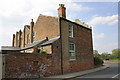
4
Magdalen's Almshouses
Unlike the other almshouses and medieval chapel across the road, there seems to be little information about this row of almshouses or the chapel beyond it. The houses must be Victorian as they are shown on a map of 1892, whilst the chapel, which also appears to be 19thC is now a private house.
Image: © Gordon Hatton
Taken: 22 Feb 2021
0.04 miles
5
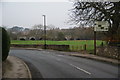
Magdalens Road, Ripon
The northern edge of Ripon. You can see the bridge over the River Ure, which is very long as it also has to cross marshy ground as well as the river.
Image: © Bill Boaden
Taken: 11 Nov 2011
0.04 miles
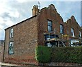
6
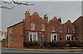
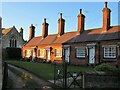
Albion Terrace
Grade II listed, built mid-C19 on Magdalen's Road in Ripon.
Image: © David Rogers
Taken: 29 Mar 2013
0.05 miles
7
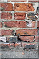
Benchmark on #24 Magdalen's Road
Ordnance Survey cut mark benchmark described on the Bench Mark Database at http://www.bench-marks.org.uk/bm48409
Image: © Roger Templeman
Taken: 7 May 2013
0.05 miles
8
#24 Magdalen's Road (Albion Terrace)
There is an OS benchmark Image on the brick wall about 1foot left of the black downpipe
Image: © Roger Templeman
Taken: 7 May 2013
0.05 miles
9
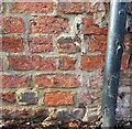
Ripon, 24 Magdalen Road
The damaged benchmark is cut across the 4th and 5th courses in the west facing wall of the above property. The datum line remains obvious, but the arrowhead is less so.
Image: © Mel Towler
Taken: 18 Nov 2022
0.05 miles
10
Ripon, 24 Magdalen Road
There is a damaged benchmark cut across the 4th and 5th courses in the west facing wall of the above property. The mark is to the left of the drainpipe. The datum line remains obvious, but the arrowhead is less so.
Image: © Mel Towler
Taken: 18 Nov 2022
0.05 miles