IMAGES TAKEN NEAR TO
Middlesmoor, HARROGATE, HG3 5TA
Introduction
This page details the photographs taken nearby to HG3 5TA by members of the Geograph project.
The Geograph project started in 2005 with the aim of publishing, organising and preserving representative images for every square kilometre of Great Britain, Ireland and the Isle of Man.

There are currently over 7.5m images from over14,400 individuals and you can help contribute to the project by visiting https://www.geograph.org.uk
Image Map (Loading...)


Getting Data...Please wait
Leaflet Map data © OpenStreetMap
Images are licensed for reuse under creativecommons.org/licenses/by-sa/2.0
Notes
- Clicking on the map will re-center to the selected point.
- The higher the marker number, the further away the image location is from the centre of the postcode.
Image Listing (13 Images Found)
Images are licensed for reuse under creativecommons.org/licenses/by-sa/2.0
Image
Details
Distance
1

Low Riggs
One of the most remote farms in Nidderdale, approached by a lengthy track from Middlesmoor. Seen across How Stean Beck from the footpath on the south side.
Image: © Gordon Hatton
Taken: 12 Mar 2009
0.03 miles
2
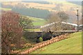
Aqueduct at Low Riggs
Carrying water from the Scar House and Angram reservoirs.
Image: © Mick Garratt
Taken: 28 Apr 2013
0.05 miles
4
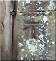
Benchmark cut into field barn, Nidderdale
The benchmark is cut into a stone to the right of the barn door, on the north-west facing wall. Wider view Image]
Image: © Mel Towler
Taken: 19 May 2023
0.15 miles
5

Field Barn near How Stean Gorge, Nidderdale
There is a benchmark cut into a stone to the right of the barn door, on the north-west facing wall. Closer view Image]
Image: © Mel Towler
Taken: 19 May 2023
0.15 miles
6
Stone rubble at end of track, Nidderdale
According to the 1909 map there was a field barn at this location with a benchmark. The barn has been demolished and a pile of rubble remains at a nearby copse.
Image: © Mel Towler
Taken: 19 May 2023
0.15 miles
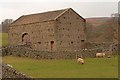
7

Field barn above How Stean Beck
A remarkably fine field barn in pastureland on the south side of How Stean Beck. Sound sandstone walls and stone 'slate' roof,and with good quality timber doors.
Image: © Gordon Hatton
Taken: 12 Mar 2009
0.16 miles
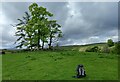
8
Path above How Stean Beck
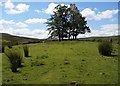
Before turning to drop down into the gorge of How Stean Beck the path approaches this small stand of trees, surrounded by a dry stone wall neither of which is not shown on the map though they must be quite old. A barn at West End Lathe is seen in the background
Image: © Christopher Hall
Taken: 10 Jul 2014
0.17 miles
9
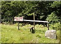
Footpath to High Riggs
After crossing the fence the footpath drops to cross How Stean Beck and then rises steeply the other side up to High Riggs. Whoever put the notice up was not joking as Imageshows
Image: © Christopher Hall
Taken: 10 Jul 2014
0.19 miles
10
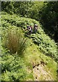
Path up from How Stean Beck
This is the footpath up to High Riggs on the opposite side from Image On the right is an un-named tributary of How Stean Beck and the gorge of the later is seen in the background.
Image: © Christopher Hall
Taken: 10 Jul 2014
0.19 miles