IMAGES TAKEN NEAR TO
Middlesmoor, HARROGATE, HG3 5SU
Introduction
This page details the photographs taken nearby to HG3 5SU by members of the Geograph project.
The Geograph project started in 2005 with the aim of publishing, organising and preserving representative images for every square kilometre of Great Britain, Ireland and the Isle of Man.

There are currently over 7.5m images from over14,400 individuals and you can help contribute to the project by visiting https://www.geograph.org.uk
Image Map (Loading...)


Getting Data...Please wait
Leaflet Map data © OpenStreetMap
Images are licensed for reuse under creativecommons.org/licenses/by-sa/2.0
Notes
- Clicking on the map will re-center to the selected point.
- The higher the marker number, the further away the image location is from the centre of the postcode.
Image Listing (6 Images Found)
Images are licensed for reuse under creativecommons.org/licenses/by-sa/2.0
Image
Details
Distance
1
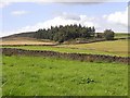
Cross Lane Plantation
Plantation in the fields above Middlesmoor.
Image: © Oliver Dixon
Taken: 7 Aug 2009
0.13 miles
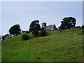
4
Cross Lane Plantation
Small plantation seen from In Moor Lane, as it gradually descends towards Middlesmoor.
Image: © Chris Heaton
Taken: 6 Jun 2007
0.20 miles
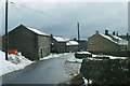
5
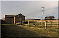
Water Supply, Middlesmoor
Middlesmoor was connected to the mains water supply only within the last few years.
Image: © David Rogers
Taken: 14 Mar 2011
0.24 miles
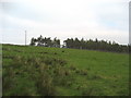
6
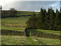
Hole In The Wall
Public footpath from Middlesmoor to Northside Head and Limley Farm.
Image: © David Rogers
Taken: 16 Feb 2011
0.24 miles