IMAGES TAKEN NEAR TO
Ramsgill, HARROGATE, HG3 5RQ
Introduction
This page details the photographs taken nearby to HG3 5RQ by members of the Geograph project.
The Geograph project started in 2005 with the aim of publishing, organising and preserving representative images for every square kilometre of Great Britain, Ireland and the Isle of Man.

There are currently over 7.5m images from over14,400 individuals and you can help contribute to the project by visiting https://www.geograph.org.uk
Image Map (Loading...)


Getting Data...Please wait
Leaflet Map data © OpenStreetMap
Images are licensed for reuse under creativecommons.org/licenses/by-sa/2.0
Notes
- Clicking on the map will re-center to the selected point.
- The higher the marker number, the further away the image location is from the centre of the postcode.
Image Listing (13 Images Found)
Images are licensed for reuse under creativecommons.org/licenses/by-sa/2.0
Image
Details
Distance
3
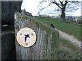
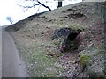
Nidderdale Way Waymark
The Curlew is the symbol of the Nidderdale Way waymarks. This one is attached to a gatepost beyond which is a track leading to West House Farm.
Image: © Roger Nunn
Taken: 20 Mar 2007
0.02 miles
5
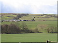
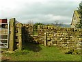
West House Farm
Fields and Land belonging to the farm taken from entrance to farm
Image: © Angela Tuff
Taken: 12 Apr 2006
0.07 miles
6
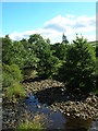
River Nidd
Taken from next to the entrance to West House Farm. The Nidd runs from Scar House reservoir along the Nidd Valley through Patley Bridge and Knaresborough and joins with the River Ouse at Nun Monkton. The confluence is seen here: Image
Image: © DS Pugh
Taken: 24 Aug 2006
0.17 miles
9
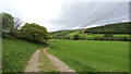
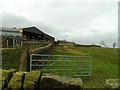
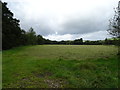
Blayshaw Lane
The Nidderdale Way, having left the public road at Ramsgill, is a public bridleway for the stretch to the minor road above How Stean Gorge opposite Lofthouse, and also serves as access to West House Farm, just behind the trees.
Image: © Andy Waddington
Taken: 21 May 2022
0.19 miles
10
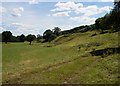
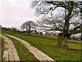
Nidderdale near High West House
The River Nidd meanders across a fairly level, wide valley and at this point has moved away from the valley side leaving the former river cliff on the right. The track across the foreground is a bridleway and part of the Nidderdale Way which keeps to the high, formerly drier land.
Image: © Christopher Hall
Taken: 9 Jul 2014
0.21 miles