IMAGES TAKEN NEAR TO
Ramsgill, HARROGATE, HG3 5RJ
Introduction
This page details the photographs taken nearby to HG3 5RJ by members of the Geograph project.
The Geograph project started in 2005 with the aim of publishing, organising and preserving representative images for every square kilometre of Great Britain, Ireland and the Isle of Man.

There are currently over 7.5m images from over14,400 individuals and you can help contribute to the project by visiting https://www.geograph.org.uk
Image Map (Loading...)


Getting Data...Please wait
Leaflet Map data © OpenStreetMap
Images are licensed for reuse under creativecommons.org/licenses/by-sa/2.0
Notes
- Clicking on the map will re-center to the selected point.
- The higher the marker number, the further away the image location is from the centre of the postcode.
Image Listing (61 Images Found)
Images are licensed for reuse under creativecommons.org/licenses/by-sa/2.0
Image
Details
Distance
1
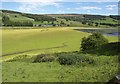
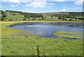
Daffodils near Gouthwaite
Looking towards Gouthwaite Reservoir near The Old Coach House.
Image: © DS Pugh
Taken: 15 Apr 2022
0.02 miles
2
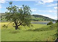
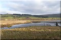
Tree and Gouthwaite Reservoir
I think the tree is an oak. Behind, the northern corner of the reservoir is covered in weed. On the other side of this, the River Nidd makes its way into the reservoir between levees. Across the valley on the hillside to the right are High Holme Farm and Moss Wood.
Image: © Derek Harper
Taken: 26 Jun 2011
0.04 miles
3
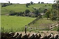
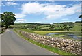
Houses near Ramsgill
Seen from the Nidderdale Way; the northern end of Gouthwaite Reservoir lies, invisible, in between.
Image: © Derek Harper
Taken: 26 Jun 2011
0.08 miles
4
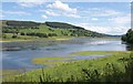
Gouthwaite Reservoir
Show as open water on maps, this northernmost 200 metres of the reservoir is now mud covered in vegetation. There is a description of the species in this area at http://www.english-nature.org.uk/citation/citation_photo/1002575.pdf : "Areas of exposed mud are being colonised by species such as bulbous rush 'Juncus bulbosus', procumbent pearlwort 'Sagina procumbens' and shoreweed 'Littorella uniflora'."
Image: © Derek Harper
Taken: 26 Jun 2011
0.09 miles
5
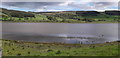
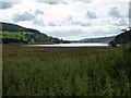
Gouthwaite near Ramsgill
Looking across the northern end of Gouthwaite Reservoir, the lower of three in Nidderdale.
Image: © DS Pugh
Taken: 27 Dec 2018
0.09 miles
6
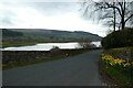
Road beside Gouthwaite Reservoir
The stretch of road from which Image was taken; the fenced viewing area is actually there at the crest of the hill but difficult to make out. The hedges alongside other viewing areas along the road are getting overgrown, making them difficult to view anything!
Image: © Derek Harper
Taken: 26 Jun 2011
0.10 miles
7
Gouthwaite Reservoir
Looking a little to the right of Image and down the reservoir; the landscape on the far side of the Nidd valley can be recognised. "The margins at the north-western end are the favoured breeding area of great crested grebe,
shoveler, ringed plover, redshank, yellow wagtail, reed bunting and meadow pipit, among others" http://www.english-nature.org.uk/citation/citation_photo/1002575.pdf . I saw lapwing, canada geese and, nost noisy of all, oystercatchers.
Image: © Derek Harper
Taken: 26 Jun 2011
0.11 miles
8
Gouthwaite Reservoir
Another view of Image from a fenced viewing area beside the road along the west side of the reservoir. There is overlap with Image Spring Wood is the prominent wood on the far slopes, left of centre.
Image: © Derek Harper
Taken: 26 Jun 2011
0.12 miles
9
Gouthwaite Reservoir
From St. Mary the Virgin churchyard.
Image: © philandju
Taken: 25 Aug 2015
0.13 miles