IMAGES TAKEN NEAR TO
Merryfields, HARROGATE, HG3 5PY
Introduction
This page details the photographs taken nearby to Merryfields, HG3 5PY by members of the Geograph project.
The Geograph project started in 2005 with the aim of publishing, organising and preserving representative images for every square kilometre of Great Britain, Ireland and the Isle of Man.

There are currently over 7.5m images from over14,400 individuals and you can help contribute to the project by visiting https://www.geograph.org.uk
Image Map (Loading...)


Getting Data...Please wait
Leaflet Map data © OpenStreetMap
Images are licensed for reuse under creativecommons.org/licenses/by-sa/2.0
Notes
- Clicking on the map will re-center to the selected point.
- The higher the marker number, the further away the image location is from the centre of the postcode.
Image Listing (8 Images Found)
Images are licensed for reuse under creativecommons.org/licenses/by-sa/2.0
Image
Details
Distance
1
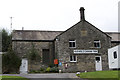
Heathfield Caravan Park
Building dated 1855.
Image: © Andrew Whale
Taken: 15 Sep 2008
0.02 miles
2
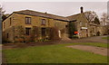
Heathfield New Smelt Mill
Built by John Yorke in 1855 to replace an earlier mill. Ore smelted here came from the Appletreewick Mining Company, Craven Moor, Burhill and Merryfield Mines.
The building that we see, constructed of well dressed masonry with sunk joints, contained two roasting hearths and four smelting hearths. By 1907 the mill had a slag hearth, two ore hearths and two reverbertory roasting furnaces. It may be that one of the roasting furnaces was used for improving or softening the lead before it was sent to the local rolling mill.
The smelters house was incorporated on the eastern end, and it is still occupied. The mill closed in 1909, making it the last of the Yorkshire Dales' smelt mills.
The building is now in use as the head office of Heathfield Caravan Park.
Image: © Matthew Hatton
Taken: 23 Jan 2016
0.03 miles
3
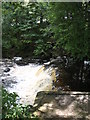
Weir on Foster Beck
One would guess that the weir was constructed in the 19th century to provide a head of water for the mill race leading to Foster Beck Mill [see photos this square]. More water came along another channel from Brandstone Beck just above its confluence with Foster Beck.
Image: © Gordon Hatton
Taken: 8 Sep 2008
0.06 miles
4
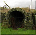
Heathfield Flue
The flue, although mostly hidden underground, is one of the longest in the Dales, winding up across pastures for over a mile and a quarter and terminating in a chimney on Heathfield Rigg. (Sadly the chimney was demolished in the late 1940's)
It was built in 1855 as part of the New Heathfield Lead Smelt Mill complex by John Yorke of Bewerley Hall.
Image: © Matthew Hatton
Taken: 23 Jan 2016
0.06 miles
5
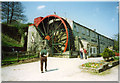
Foster Beck Watermill, Pateley Bridge
A breastshot wheel originally used to power a woollen mill.
Image: © Chris Coleman
Taken: Unknown
0.13 miles
6
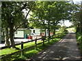
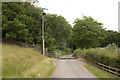
Heathfield Caravan Site
Caravan site in a scenic location for static and touring vans. The tarmac road is also a bridleway.
Image: © Gordon Hatton
Taken: 8 Sep 2008
0.14 miles
7
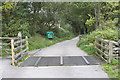
Cattle grid near Heathfield Caravan Park
Image: © Andrew Whale
Taken: 15 Sep 2008
0.17 miles