IMAGES TAKEN NEAR TO
Wath, HARROGATE, HG3 5PS
Introduction
This page details the photographs taken nearby to HG3 5PS by members of the Geograph project.
The Geograph project started in 2005 with the aim of publishing, organising and preserving representative images for every square kilometre of Great Britain, Ireland and the Isle of Man.

There are currently over 7.5m images from over14,400 individuals and you can help contribute to the project by visiting https://www.geograph.org.uk
Image Map (Loading...)


Getting Data...Please wait
Leaflet Map data © OpenStreetMap
Images are licensed for reuse under creativecommons.org/licenses/by-sa/2.0
Notes
- Clicking on the map will re-center to the selected point.
- The higher the marker number, the further away the image location is from the centre of the postcode.
Image Listing (5 Images Found)
Images are licensed for reuse under creativecommons.org/licenses/by-sa/2.0
Image
Details
Distance
1
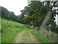
Climbing above Gouthwaite
This rough track allows access around the northern edge of Gouthwaite reservoir.
Image: © DS Pugh
Taken: 8 Sep 2009
0.16 miles
2
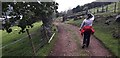
The Nidderdale Way near Gouthwaite Reservoir
Image: © Anthony Parkes
Taken: 26 May 2019
0.16 miles
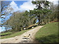
4
Yates Wood and Tenement Wood
Above Gouthwaite Reservoir.
Image: © Malcolm Street
Taken: 11 Nov 2005
0.22 miles
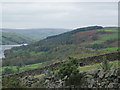
5
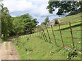
On the Nidderdale Way
Approaching the northern edge of the square; the barn on the right is in Image
Image: © Derek Harper
Taken: 26 Jun 2011
0.25 miles