IMAGES TAKEN NEAR TO
St. Marys Estate, HARROGATE, HG3 5NR
Introduction
This page details the photographs taken nearby to St. Marys Estate, HG3 5NR by members of the Geograph project.
The Geograph project started in 2005 with the aim of publishing, organising and preserving representative images for every square kilometre of Great Britain, Ireland and the Isle of Man.

There are currently over 7.5m images from over14,400 individuals and you can help contribute to the project by visiting https://www.geograph.org.uk
Image Map (352 Images)


Leaflet Map data © OpenStreetMap
Images are licensed for reuse under creativecommons.org/licenses/by-sa/2.0
Notes
- Clicking on the map will re-center to the selected point.
- The higher the marker number, the further away the image location is from the centre of the postcode.
Image Listing (352 Images Found)
Images are licensed for reuse under creativecommons.org/licenses/by-sa/2.0
Image
Details
Distance
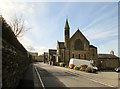
1
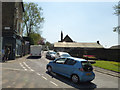
Ripon Road, Pateley Bridge
This is effectively an extension of the High Street, with a constant procession of traffic through the town centre - the topography of the area precludes building a bypass. The church in the distance is a Methodist one.
Image: © Stephen Craven
Taken: 7 May 2018
0.02 miles
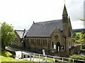
2
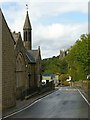
Spire and tower, Pateley Bridge
Methodist (left) and Anglican churches, on Ripon Road.
Image: © Alan Murray-Rust
Taken: 9 Sep 2017
0.03 miles
3
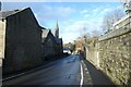
Pateley Bridge Methodists Church
Looking along Ripon Road in Pateley Bridge.
Image: © DS Pugh
Taken: 1 Jan 2023
0.04 miles
4
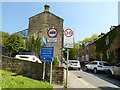
Signs at the bottom of Old Church Lane
The signs warn drivers of large, long or wide vehicles against attempting this steep and narrow road. Cyclists heading for Ripon on the Way of the Roses are also directed right along the gentler gradient of Ripon Road.
Image: © Stephen Craven
Taken: 7 May 2018
0.04 miles
5
![Pateley Bridge features [1]](https://s2.geograph.org.uk/geophotos/07/03/09/7030942_6b139019_120x120.jpg)
Pateley Bridge features [1]
This well was originally erected in 1852 on Ripon Road and was known as Souter Well. Moved to its present position in the 1970s and now known as Fox's Head Well.
Built of stone with a stone trough with cast-iron fox's head spout above. Listed, grade II, with details at: https://historicengland.org.uk/listing/the-list/list-entry/1150506
Pateley Bridge is a small market town, the market charter being granted in 1320. Located on the banks of the River Nidd, the town is some 11 miles northwest of Harrogate, some 10 miles southwest of Ripon and is within the Nidderdale Area of Outstanding Natural Beauty. The town is popular with tourists exploring the Yorkshire Dales.
Image: © Michael Dibb
Taken: 23 Jun 2021
0.04 miles
6
Methodist Church Ripon Road Pateley Bridge
Image: © Martin Dawes
Taken: 4 May 2016
0.04 miles
7
Pateley Bridge Methodist Church
An imposing church in Victorian Gothic style.
There is a bench mark http://www.geograph.org.uk/photo/5536639 on the gable of the Sunday school extension to the left of the main church.
Image: © Alan Murray-Rust
Taken: 9 Sep 2017
0.04 miles
8
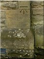
Bench mark, Pateley Bridge Methodist Church
See http://www.geograph.org.uk/photo/5536644 for location.
Image: © Alan Murray-Rust
Taken: 9 Sep 2017
0.04 miles
9
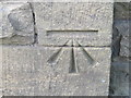
Ordnance Survey Cut Mark
This mark can be found on the wall of the Methodist Chapel in Ripon Road.
For more detail see : http://www.bench-marks.org.uk/bm45697
Image: © Peter Wood
Taken: 22 Sep 2012
0.04 miles
10
Old Church Lane, Pateley Bridge
Footpath beside Old Church Lane in Pateley Bridge.
Image: © Philip Halling
Taken: 10 Jun 2013
0.05 miles