IMAGES TAKEN NEAR TO
The Knott, HARROGATE, HG3 5NH
Introduction
This page details the photographs taken nearby to The Knott, HG3 5NH by members of the Geograph project.
The Geograph project started in 2005 with the aim of publishing, organising and preserving representative images for every square kilometre of Great Britain, Ireland and the Isle of Man.

There are currently over 7.5m images from over14,400 individuals and you can help contribute to the project by visiting https://www.geograph.org.uk
Image Map (Loading...)


Getting Data...Please wait
Leaflet Map data © OpenStreetMap
Images are licensed for reuse under creativecommons.org/licenses/by-sa/2.0
Notes
- Clicking on the map will re-center to the selected point.
- The higher the marker number, the further away the image location is from the centre of the postcode.
Image Listing (20 Images Found)
Images are licensed for reuse under creativecommons.org/licenses/by-sa/2.0
Image
Details
Distance
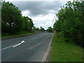
5
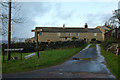
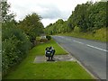
B6265 Ripley Bank at Pateley Bridge boundary
Image: © Colin Pyle
Taken: 1 Nov 2015
0.15 miles
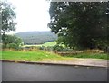
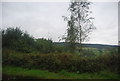
6
The entry to Pateley Bridge
Currently there is not much of a view from the seat as the hedge has been allowed to grow. On the B6265, Ripley Bank.
Image: © Alan Murray-Rust
Taken: 9 Sep 2017
0.15 miles
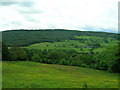
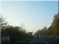
7
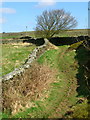
Tenter Hill Path
Public Bridleway from Knott Farm towards Quarry House.
Image: © David Rogers
Taken: 2 Apr 2009
0.16 miles