IMAGES TAKEN NEAR TO
Pateley Bridge, HARROGATE, HG3 5NE
Introduction
This page details the photographs taken nearby to HG3 5NE by members of the Geograph project.
The Geograph project started in 2005 with the aim of publishing, organising and preserving representative images for every square kilometre of Great Britain, Ireland and the Isle of Man.

There are currently over 7.5m images from over14,400 individuals and you can help contribute to the project by visiting https://www.geograph.org.uk
Image Map (Loading...)


Getting Data...Please wait
Leaflet Map data © OpenStreetMap
Images are licensed for reuse under creativecommons.org/licenses/by-sa/2.0
Notes
- Clicking on the map will re-center to the selected point.
- The higher the marker number, the further away the image location is from the centre of the postcode.
Image Listing (11 Images Found)
Images are licensed for reuse under creativecommons.org/licenses/by-sa/2.0
Image
Details
Distance
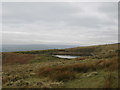
3
View over rough pasture
Sign of old workings in this field
Image: © Martin Dawes
Taken: 13 Jul 2014
0.09 miles
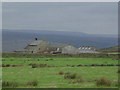
5
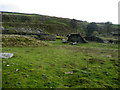
Disused Quarries at Scot Gate Ash
Extensive abandoned quarries high above Pateley Bridge and Nidderdale.
Image: © Chris Heaton
Taken: 22 Oct 2008
0.18 miles
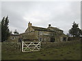
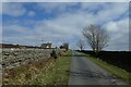
6
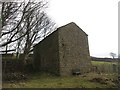
Barn at Scot Gate Ash, above Pateley Bridge
Image: © John Slater
Taken: 12 Mar 2016
0.20 miles
7
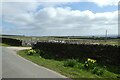
Daffodils and footpath from Wath Lane
The footpath heads towards Pateley Bridge.
Image: © DS Pugh
Taken: 3 Apr 2021
0.21 miles
8
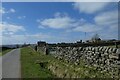
Wath Lane near Somerset House
Looking along Wath Lane towards Wath.
Image: © DS Pugh
Taken: 3 Apr 2021
0.23 miles
9
Approaching Somerset House
Looking along Wath Lane.
Image: © DS Pugh
Taken: 3 Apr 2021
0.23 miles
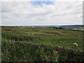
10

Minor road heading east toward Brownstay Ridge
Image: © Martin Dawes
Taken: 13 Jul 2014
0.24 miles