IMAGES TAKEN NEAR TO
Nidd Walk, HARROGATE, HG3 5NA
Introduction
This page details the photographs taken nearby to Nidd Walk, HG3 5NA by members of the Geograph project.
The Geograph project started in 2005 with the aim of publishing, organising and preserving representative images for every square kilometre of Great Britain, Ireland and the Isle of Man.

There are currently over 7.5m images from over14,400 individuals and you can help contribute to the project by visiting https://www.geograph.org.uk
Image Map (Loading...)


Getting Data...Please wait
Leaflet Map data © OpenStreetMap
Images are licensed for reuse under creativecommons.org/licenses/by-sa/2.0
Notes
- Clicking on the map will re-center to the selected point.
- The higher the marker number, the further away the image location is from the centre of the postcode.
Image Listing (368 Images Found)
Images are licensed for reuse under creativecommons.org/licenses/by-sa/2.0
Image
Details
Distance
1
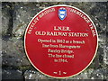
Pateley Bridge Trail Plaque
This sign commemorates the site of the old railway station at Pateley Bridge
Image: © Chris Heaton
Taken: 1 Jan 2007
0.03 miles
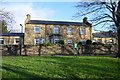
4
Pateley Bridge railway station (site), Yorkshire
Opened in 1862 by the North Eastern Railway as the terminus of its line from Harrogate, the station closed to passengers in 1950. The single platform was situated in front of the building, roughly where the wall now is, with sidings further to the left. A single track continued across the road junction in the distance to make a connection with the Nidd Valley Light Railway which had a passenger service as far as Lofthouse-in-Nidderdale between 1907 and 1929.
Image: © Nigel Thompson
Taken: 23 Feb 2013
0.04 miles
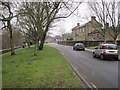
5
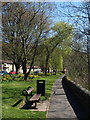
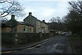
Riverside path, Pateley Bridge
Following footpath 15 58/52/2 downstream on the left bank of the River Nidd, past a pleasant lawn with trees, daffodils and seats. The houses on the left are addressed, reasonably, Nidd Walk.
Image: © Derek Harper
Taken: 5 Apr 2012
0.04 miles
6
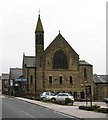
Pateley Bridge Methodist Church
The church stands at the top end of the little town and was built in 1909, replacing an earlier chapel of 1777. John Wesley preached in the old chapel and the original pulpit is preserved within the present church.
Image: © Gordon Hatton
Taken: 2 Jun 2008
0.05 miles
7
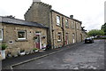
The former railway station building at Pateley Bridge (2)
This is the North Eastern Railway (NER) station opened to traffic in 1862. Passenger traffic stopped in 1951 and to freight in 1964. This is a view of the station entrance side - the trains would have been on the other side - see my other picture Image The stepped gables typical of the NER are very distinctive.
The building has been converted into old people's accommodation.
Image: © John Webb
Taken: 8 Jun 2011
0.05 miles
8
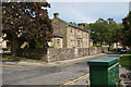
The former railway station building at Pateley Bridge (1)
This is the station building erected by the North-Eastern Railway and opened to traffic in 1862. It was the terminus of a branch line which left the Leeds Northern main line at Ripley Junction. This is the platform side; the station entrance side can be seen at Image
The building has been converted into old people's accommodation.
On the far right of the station site a line ran to the other end of Pately Bridge to connect with the Nidd Valley Light railway erected in the early 1900s by Bradford Corporation in connection with the construction of Angram and Scar House reservoirs.
Image: © John Webb
Taken: 8 Jun 2011
0.05 miles
9
Former railway station
Looking along Nidd Walk at the site of the former railway station serving Pateley Bridge.
Image: © DS Pugh
Taken: 1 Jan 2023
0.05 miles
10
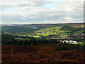
Nidderdale and Pateley Bridge, North Yorkshire
View of the village Pateley Bridge: to the right of the image are the temporary white marquees installed for the annual agricultural show.
Image: © Jim Osley
Taken: 17 Sep 2010
0.05 miles