IMAGES TAKEN NEAR TO
King Street, HARROGATE, HG3 5LE
Introduction
This page details the photographs taken nearby to King Street, HG3 5LE by members of the Geograph project.
The Geograph project started in 2005 with the aim of publishing, organising and preserving representative images for every square kilometre of Great Britain, Ireland and the Isle of Man.

There are currently over 7.5m images from over14,400 individuals and you can help contribute to the project by visiting https://www.geograph.org.uk
Image Map (Loading...)


Getting Data...Please wait
Leaflet Map data © OpenStreetMap
Images are licensed for reuse under creativecommons.org/licenses/by-sa/2.0
Notes
- Clicking on the map will re-center to the selected point.
- The higher the marker number, the further away the image location is from the centre of the postcode.
Image Listing (303 Images Found)
Images are licensed for reuse under creativecommons.org/licenses/by-sa/2.0
Image
Details
Distance
2
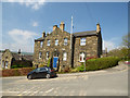
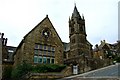
Nidderdale Museum, Pateley Bridge
See also Image
Image: © Stephen Craven
Taken: 7 May 2018
0.01 miles
3
Nidderdale Museum
Looking towards the entrance of the Nidderdale Museum.
Image: © DS Pugh
Taken: 3 Apr 2021
0.01 miles
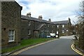
4
Nidderdale Museum
Looking towards the Nidderdale Museum in Pateley Bridge.
Image: © DS Pugh
Taken: 1 Jan 2023
0.02 miles
5
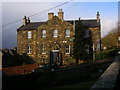
![Pateley Bridge buildings [13]](https://s1.geograph.org.uk/geophotos/07/03/18/7031829_2393605c_120x120.jpg)
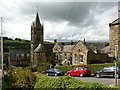
Pateley Bridge buildings [13]
This fine 'H' shaped building is a fine example of how one building can have many uses of the years. Constructed of squared, coursed stone with freestone dressings under a slate roof.
Built as a Union Workhouse in 1863, it could accommodate 80 inmates. The workhouse closed in 1914. The building house German prisoners of war during WWI and later workers on the Scar Dam project. Occupied as offices by the Water Board and the Ripon and Pateley Bridge Rural District Council. Part of the building is now the Nidderdale Museum, other parts are in commercial use.
Pateley Bridge is a small market town, the market charter being granted in 1320. Located on the banks of the River Nidd, the town is some 11 miles northwest of Harrogate, some 10 miles southwest of Ripon and is within the Nidderdale Area of Outstanding Natural Beauty. The town is popular with tourists exploring the Yorkshire Dales.
Image: © Michael Dibb
Taken: 23 Jun 2021
0.02 miles
6
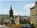
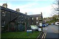
St Cuthbert's church school, Pateley Bridge
I assumed this was a church, because of the spire, until I looked more closely. Another contributor gives its interesting history at Image
Image: © Stephen Craven
Taken: 7 May 2018
0.02 miles
7
Gothic evidence
Victorian built school buildings in Pateley Bridge.
Image: © Donnylad
Taken: 25 Jul 2007
0.02 miles
8

King Street
Looking towards the school in Pateley Bridge.
Image: © DS Pugh
Taken: 1 Apr 2013
0.02 miles
9
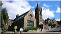
St Cuthbert's School
St Cuthbert's is a Church of England primary school for boys and girls aged from 3 to 11.
Image: © Mark Percy
Taken: 24 Jul 2020
0.02 miles
10
Pateley Bridge, St Cuthbert's primary school
This must be one of the more impressive primary schools in the country with its tower and spire. It originated as a board school in 1875 before becoming the local secondary modern school in 1948, then with rationalisation of secondary schools in the late 20th century it reverted simply to being a primary school.
Image: © Alan Murray-Rust
Taken: 9 Sep 2017
0.02 miles