IMAGES TAKEN NEAR TO
Southlands, HARROGATE, HG3 5JX
Introduction
This page details the photographs taken nearby to Southlands, HG3 5JX by members of the Geograph project.
The Geograph project started in 2005 with the aim of publishing, organising and preserving representative images for every square kilometre of Great Britain, Ireland and the Isle of Man.

There are currently over 7.5m images from over14,400 individuals and you can help contribute to the project by visiting https://www.geograph.org.uk
Image Map (372 Images)


Getting Data...Please wait
Leaflet Map data © OpenStreetMap
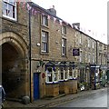
Images are licensed for reuse under creativecommons.org/licenses/by-sa/2.0
Notes
- Clicking on the map will re-center to the selected point.
- The higher the marker number, the further away the image location is from the centre of the postcode.
Image Listing (372 Images Found)
Images are licensed for reuse under creativecommons.org/licenses/by-sa/2.0
Image
Details
Distance
1
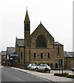
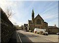
Pateley Bridge Methodist Church
The church stands at the top end of the little town and was built in 1909, replacing an earlier chapel of 1777. John Wesley preached in the old chapel and the original pulpit is preserved within the present church.
Image: © Gordon Hatton
Taken: 2 Jun 2008
0.00 miles
2
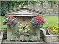
Foxes Head Well, Pateley Bridge
Originally erected in 1852 on Ripon Road as Souter Well, it was moved to the present site in 1870's and is now known as Foxes Head Well because of the foxes head spout in the centre.
Image: © Peter Worrell
Taken: 25 Jul 2007
0.03 miles
3
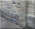
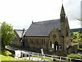
Pateley Bridge Methodist church
The benchmark is cut into the north-east face of the church.
Image: © Mel Towler
Taken: 7 Nov 2021
0.03 miles
4
Pateley Bridge, Methodist church
There is a benchmark cut into the north-east face of the church.
Image: © Mel Towler
Taken: 7 Nov 2021
0.03 miles
5
Methodist Church Ripon Road Pateley Bridge
Image: © Martin Dawes
Taken: 4 May 2016
0.04 miles
6
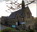
Pateley Bridge Methodist Church
An imposing church in Victorian Gothic style.
There is a bench mark http://www.geograph.org.uk/photo/5536639 on the gable of the Sunday school extension to the left of the main church.
Image: © Alan Murray-Rust
Taken: 9 Sep 2017
0.04 miles
7
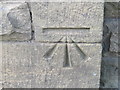
Ordnance Survey Cut Mark
This mark can be found on the wall of the Methodist Chapel in Ripon Road.
For more detail see : http://www.bench-marks.org.uk/bm45697
Image: © Peter Wood
Taken: 22 Sep 2012
0.04 miles
8
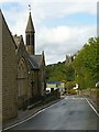
Spire and tower, Pateley Bridge
Methodist (left) and Anglican churches, on Ripon Road.
Image: © Alan Murray-Rust
Taken: 9 Sep 2017
0.04 miles
9
The old George Inn, High Street, Pateley Bridge
Latterly the Pateley Club and prior to that the Conservative Club, but currently unoccupied. The building is dated 1664 http://www.geograph.org.uk/photo/5536571 and started life as the George and Dragon. The bay windows are a 19th century addition. Listed Grade II.
Image: © Alan Murray-Rust
Taken: 9 Sep 2017
0.05 miles
10
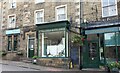
Pateley Bridge, High Street
According to the OS benchmark database there is a benchmark cut into the wall between the 2 large shop windows. The blackboard is covering the mark, but it was last viewed and recorded in 2012.
Image: © Mel Towler
Taken: 11 Sep 2022
0.05 miles