IMAGES TAKEN NEAR TO
Bewerley, HARROGATE, HG3 5HS
Introduction
This page details the photographs taken nearby to HG3 5HS by members of the Geograph project.
The Geograph project started in 2005 with the aim of publishing, organising and preserving representative images for every square kilometre of Great Britain, Ireland and the Isle of Man.

There are currently over 7.5m images from over14,400 individuals and you can help contribute to the project by visiting https://www.geograph.org.uk
Image Map (Loading...)


Getting Data...Please wait
Leaflet Map data © OpenStreetMap
Images are licensed for reuse under creativecommons.org/licenses/by-sa/2.0
Notes
- Clicking on the map will re-center to the selected point.
- The higher the marker number, the further away the image location is from the centre of the postcode.
Image Listing (68 Images Found)
Images are licensed for reuse under creativecommons.org/licenses/by-sa/2.0
Image
Details
Distance
1
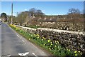
The Green, Bewerley
The green and its houses are also shown in http://www.geograph.org.uk/gridref/SE1564?centi=SE157649 . Here daffodils line the wall by the road from Nought Bank.
Image: © Derek Harper
Taken: 5 Apr 2012
0.05 miles

3
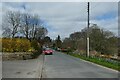
Road through Bewerley
Looking along the road through Bewerley heading to Pateley Bridge.
Image: © DS Pugh
Taken: 3 Apr 2021
0.06 miles
4
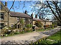
The Green, Bewerley
An attractive line of cottages alongside the triangular green, passed by the Nidderdale Way.
Image: © Derek Harper
Taken: 5 Apr 2012
0.06 miles
6

Bewerley, bridge
There is a benchmark cut into the western parapet of the bridge on the lowest course of stone.
Image: © Mel Towler
Taken: 7 Nov 2021
0.07 miles
7
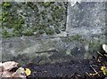
Bewerley, bridge
There is a benchmark cut into the western parapet of the bridge on the lowest course of stone.
Image: © Mel Towler
Taken: 7 Nov 2021
0.07 miles
8
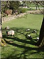
Sheep near Pateley Bridge
Ewes and lambs in the field to the right of the stretch of road shown in Image The field, with trees at the top, drops down to the valley floor and the Bewerley Park Centre For Outdoor Education.
Image: © Derek Harper
Taken: 5 Apr 2012
0.07 miles
9
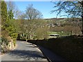
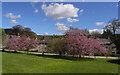
Road to Pateley Bridge
The road from Bewerley curves down to cross the Rash Dike, with a glimpse of part of Bewerley Park Centre For Outdoor Education on the valley floor of the Nidd, and the town of Pateley Bridge beyond.
Image: © Derek Harper
Taken: 5 Apr 2012
0.07 miles
10
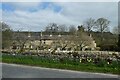
Cottages in Bewerley
Looking across the green towards some cottages in Bewerley.
Image: © DS Pugh
Taken: 3 Apr 2021
0.07 miles