IMAGES TAKEN NEAR TO
Fellbeck, HARROGATE, HG3 5EW
Introduction
This page details the photographs taken nearby to HG3 5EW by members of the Geograph project.
The Geograph project started in 2005 with the aim of publishing, organising and preserving representative images for every square kilometre of Great Britain, Ireland and the Isle of Man.

There are currently over 7.5m images from over14,400 individuals and you can help contribute to the project by visiting https://www.geograph.org.uk
Image Map (Loading...)


Getting Data...Please wait
Leaflet Map data © OpenStreetMap
Images are licensed for reuse under creativecommons.org/licenses/by-sa/2.0
Notes
- Clicking on the map will re-center to the selected point.
- The higher the marker number, the further away the image location is from the centre of the postcode.
Image Listing (9 Images Found)
Images are licensed for reuse under creativecommons.org/licenses/by-sa/2.0
Image
Details
Distance
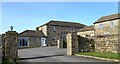
1

Pateley Bridge, New Causeway Farm
The benchmark is cut into a gatepost on the right hand side of the entrance to the farm.
Image: © Mel Towler
Taken: 17 Feb 2023
0.05 miles
2

Pateley Bridge, New Causeway Farm
There is a benchmark cut into the gatepost at the left end of the far wall, at the entrance to the farm.
Image: © Mel Towler
Taken: 17 Feb 2023
0.05 miles
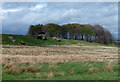
3
Pateley Bridge, Gully Farm
According to the OS benchmark database there is a benchmark cut into the east face of the converted farm building. No view was possible from the roadside.
Image: © Mel Towler
Taken: 17 Feb 2023
0.11 miles
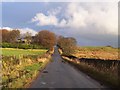
4
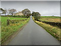
Road on Hollin Hill
Approaching Madge Hill Farm
Image: © Chris Heaton
Taken: 21 Oct 2011
0.13 miles
5
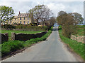
Country road near Pateley Bridge (6)
Passing Madge Hill Farm.
Image: © Stephen Richards
Taken: 15 May 2013
0.16 miles
6
Glasshouses, Blazefield
According to the OS benchmark database there is a benchmark cut into the wall just south of the wall junction. Nothing was found.
Image: © Mel Towler
Taken: 17 Feb 2023
0.20 miles
7
Madge Hill Crag near Pateley Bridge
Image: © Stephen Richards
Taken: 15 May 2013
0.20 miles
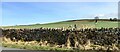
8
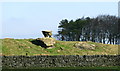
Madge Hill Crag
Weather eroded stone near Madge Hill Farm.
Image: © David Rogers
Taken: 2 Apr 2009
0.22 miles
9
Road at Madge Hill Farm
The road that leads from Blazefield on the B6265, crossing Dallowgill Moor to Kirkby Malzeard.
Image: © Chris Heaton
Taken: 6 Dec 2005
0.22 miles