IMAGES TAKEN NEAR TO
Pateley Bridge, HARROGATE, HG3 5DP
Introduction
This page details the photographs taken nearby to HG3 5DP by members of the Geograph project.
The Geograph project started in 2005 with the aim of publishing, organising and preserving representative images for every square kilometre of Great Britain, Ireland and the Isle of Man.

There are currently over 7.5m images from over14,400 individuals and you can help contribute to the project by visiting https://www.geograph.org.uk
Image Map
Images are licensed for reuse under creativecommons.org/licenses/by-sa/2.0
Notes
- Clicking on the map will re-center to the selected point.
- The higher the marker number, the further away the image location is from the centre of the postcode.
Image Listing (41 Images Found)
Images are licensed for reuse under creativecommons.org/licenses/by-sa/2.0
Image
Details
Distance
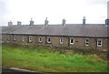
2
Terraced cottages, Blazefield
Looking down the hillside over a row of Victorian cottages, most likely built for quarrymen.
Image: © Gordon Hatton
Taken: 23 Sep 2008
0.04 miles
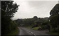
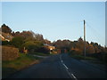
4
Blazefield, roadside barn
The benchmark is cut into the north face of the barn, and is roadside on the south side of the B6265.
Image: © Mel Towler
Taken: 6 Aug 2022
0.07 miles
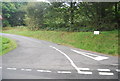
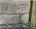
5
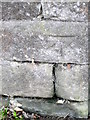
Bench Mark, Rock House
The Ordnance Survey bench mark is on the north west angle of an outbuilding at Rock House. For a wider view of the building Image and for further information on the cut mark and others in the area http://www.bench-marks.org.uk/bm39254
Image: © Maigheach-gheal
Taken: 6 Apr 2011
0.07 miles
6
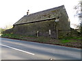
Outbuilding at Rock House
The building is beside the B6265 and it has an Ordnance Survey bench mark on the north west angle.
Image: © Maigheach-gheal
Taken: 6 Apr 2011
0.07 miles
7
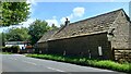
Blazefield, roadside barn
There is a benchmark cut into the north face of the barn which is located on the south side of the B6265. The cutmark is to the right of the white meter box.
Image: © Mel Towler
Taken: 6 Aug 2022
0.07 miles
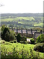
8
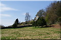
Field below the Nidderdale Way
This looks more like a garden than farmland. The Nidderdale Way runs on the other side of the wall. The houses have excellent views across Nidderdale. You can see the chimneys of the long terrace at Blazefield.
Image: © Bill Boaden
Taken: 6 May 2013
0.07 miles