IMAGES TAKEN NEAR TO
Nidd Terrace, HARROGATE, HG3 4JL
Introduction
This page details the photographs taken nearby to Nidd Terrace, HG3 4JL by members of the Geograph project.
The Geograph project started in 2005 with the aim of publishing, organising and preserving representative images for every square kilometre of Great Britain, Ireland and the Isle of Man.

There are currently over 7.5m images from over14,400 individuals and you can help contribute to the project by visiting https://www.geograph.org.uk
Image Map (Loading...)


Getting Data...Please wait
Leaflet Map data © OpenStreetMap
Images are licensed for reuse under creativecommons.org/licenses/by-sa/2.0
Notes
- Clicking on the map will re-center to the selected point.
- The higher the marker number, the further away the image location is from the centre of the postcode.
Image Listing (58 Images Found)
Images are licensed for reuse under creativecommons.org/licenses/by-sa/2.0
Image
Details
Distance
1
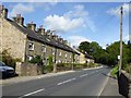
Terrace of cottages in Summerbridge
On the B6165 at the northern end of the town.
Image: © philandju
Taken: 25 Aug 2015
0.01 miles
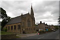
2
B6165 nears Summerbridge Methodist Church
Image: © Colin Pyle
Taken: 1 Nov 2015
0.01 miles
3
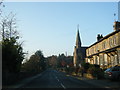
Northwest Summerbridge
The northwest side of the village, with buildings along the B6165, seen from bridleway 15 55/73/1. The spire belongs to Summerbridge Methodist Church (Image).
Image: © Derek Harper
Taken: 5 Apr 2012
0.03 miles
4
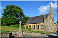
Summerbridge Methodist Church and war memorial
Image: © David Martin
Taken: 21 Jun 2013
0.04 miles
7
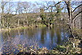
Grassy track, New York
Leading up from bridleway 15 55/73/1 to the B6165.
Image: © Derek Harper
Taken: 5 Apr 2012
0.07 miles
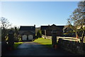
8
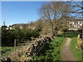
Bridleway, New York
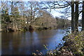
Bridleway 15 55/73/1 runs between housing at New York and a young plantation by the River Nidd.
Image: © Derek Harper
Taken: 5 Apr 2012
0.08 miles