IMAGES TAKEN NEAR TO
Dacre, HARROGATE, HG3 4ES
Introduction
This page details the photographs taken nearby to HG3 4ES by members of the Geograph project.
The Geograph project started in 2005 with the aim of publishing, organising and preserving representative images for every square kilometre of Great Britain, Ireland and the Isle of Man.

There are currently over 7.5m images from over14,400 individuals and you can help contribute to the project by visiting https://www.geograph.org.uk
Image Map (Loading...)


Getting Data...Please wait
Leaflet Map data © OpenStreetMap
Images are licensed for reuse under creativecommons.org/licenses/by-sa/2.0
Notes
- Clicking on the map will re-center to the selected point.
- The higher the marker number, the further away the image location is from the centre of the postcode.
Image Listing (29 Images Found)
Images are licensed for reuse under creativecommons.org/licenses/by-sa/2.0
Image
Details
Distance
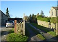
2
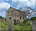
Dacre Hall
An odd looking building. It appears to be mostly 18th century, but with an odd sort of Victorian tower in the middle. It is Grade II listed; the English Heritage listing says:
"House. Late C18 with late C19 alterations. Ashlar, stone slate roof. 2 storeys, 3 bays. 3 steps up to central C20 glazed door with overlight in reeded surround with deep cornice. Flanking windows on each floor. 16-pane sashes, projecting sills, incised lintels. First floor, centre: sash with glazing bars. Moulded stone gutter, gable coping, end stacks.
Interior: original staircase lit by round-arched sash window with glazing bars. 6-panel doors. Similar in style to Pyefield House (qv). An inscription now built above a window in the attached range of buildings states 'This building erected by William and Jane Skaife AD 1795'. It was probably removed from the house when the entrance was altered in the late C19."
(English Heritage building ID 331176)
Image: © Gordon Hatton
Taken: 6 Jan 2008
0.05 miles
3
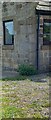
Benchmark cut into house wall, Dacre
The benchmark is cut into a right cornerstone of the west facing wall of The Mistal property. The cutmark can be seen above the small, green shrub. Wider view Image]
Image: © Mel Towler
Taken: 26 May 2023
0.05 miles
4
Mistal House, Dacre
There is a benchmark cut into a right cornerstone of the west facing wall of The Mistal property. The cutmark can be seen above the small, green shrub. Closer view Image]
Image: © Mel Towler
Taken: 26 May 2023
0.05 miles
5
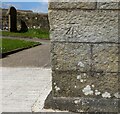
Benchmark cut into chapel, Dacre
The benchmark is cut into a left cornerstone of the south facing wall of the Providence Chapel in Dacre. Wider view Image]
Image: © Mel Towler
Taken: 26 May 2023
0.05 miles
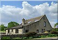
6
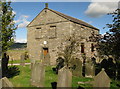
Providence Chapel, Dacre
Erected in 1827 as an Independent Chapel and now apparently the only United Reformed Church in Nidderdale. Grade II listed.
Image: © David Rogers
Taken: 20 Sep 2010
0.06 miles
7
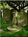
Providence Chapel Churchyard.
Grade II listed sundial inscribed with the date 1828. A similar
sundial dated 1826 stands in the churchyard of St Jude's, Hartwith.
Image: © David Rogers
Taken: 22 Sep 2010
0.06 miles
8
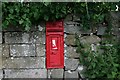
Victorian Postbox at Dacre.
This box has been sealed and a modern one is situated just across the road.
Image: © Steve Partridge
Taken: 1 Jul 2007
0.06 miles
9
Providence Chapel, Dacre
There is a benchmark cut into a left cornerstone of the south facing wall of the Providence Chapel in Dacre. Closer view Image]
Image: © Mel Towler
Taken: 26 May 2023
0.06 miles
10
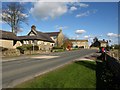
B6451 at Dacre
Approaching the junction with Dacre Lane. The telephone box is shown in Image
Image: © Derek Harper
Taken: 5 Apr 2012
0.08 miles