IMAGES TAKEN NEAR TO
Dacre, HARROGATE, HG3 4AQ
Introduction
This page details the photographs taken nearby to HG3 4AQ by members of the Geograph project.
The Geograph project started in 2005 with the aim of publishing, organising and preserving representative images for every square kilometre of Great Britain, Ireland and the Isle of Man.

There are currently over 7.5m images from over14,400 individuals and you can help contribute to the project by visiting https://www.geograph.org.uk
Image Map (Loading...)


Getting Data...Please wait
Leaflet Map data © OpenStreetMap
Images are licensed for reuse under creativecommons.org/licenses/by-sa/2.0
Notes
- Clicking on the map will re-center to the selected point.
- The higher the marker number, the further away the image location is from the centre of the postcode.
Image Listing (11 Images Found)
Images are licensed for reuse under creativecommons.org/licenses/by-sa/2.0
Image
Details
Distance
1
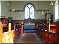
St Saviour's Church, Thornthwaite - inside
Image: © Malcolm Street
Taken: 22 Sep 2005
0.20 miles
2
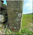
Padside, Dacre Lane
The benchmark is cut into the left hand gatepost on the east side of Dacre Lane.
Image: © Mel Towler
Taken: 8 Apr 2023
0.20 miles
3
Padside, Dacre Lane
There is a benchmark cut into the left hand gatepost on the east side of Dacre Lane.
Image: © Mel Towler
Taken: 8 Apr 2023
0.20 miles
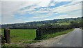
4
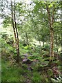
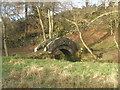
Woodland Path by Padside Beck
The acid soils in this area favour birch trees and bracken, whilst there are plenty of gritstone rocks to trip over.
Image: © Gordon Hatton
Taken: 17 Aug 2011
0.20 miles
5
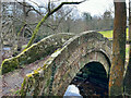
Packhorse Bridge
The ancient packhorse bridge, also known as 'Fairy Bridge'.
Image: © Stu Mitchell
Taken: 25 Feb 2023
0.22 miles
6
Packhorse bridge over Padside Beck
If this is a packhorse bridge, why is it crossed by a footpath not a bridleway?
Image: © John Slater
Taken: 11 Dec 2012
0.23 miles
7
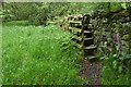
Thornthwaite: Stile close to Packhorse Bridge
Image: © Michael Garlick
Taken: 2 Aug 2019
0.24 miles
8

Thornthwaite: Stile close to Packhorse Bridge
Image: © Michael Garlick
Taken: 2 Aug 2019
0.24 miles
9
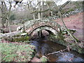
Packhorse Bridge at Thornthwaite
This ancient bridge spans Padside Beck and has the low parapets typical of packhorse bridges.
Image: © Gordon Hatton
Taken: 4 Feb 2008
0.24 miles
10
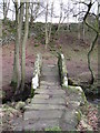
Thornthwaite packhorse bridge
Looking for references about this bridge, one comes across conflicting information. One source suggest that the bridge is on an old trade route between Ilkley and Ripon, whilst another puts the bridge on a monastic route between Bolton Priory and Fountains Abbey. The latter seems the more likely as the bridge lines up with old tracks radiating from Fountains, and the path/track etc NE from here goes along Monk Ing Road towards an old river crossing at Summerbridge.
Image: © Gordon Hatton
Taken: 4 Feb 2008
0.24 miles