IMAGES TAKEN NEAR TO
Wormald Green, HARROGATE, HG3 3PT
Introduction
This page details the photographs taken nearby to HG3 3PT by members of the Geograph project.
The Geograph project started in 2005 with the aim of publishing, organising and preserving representative images for every square kilometre of Great Britain, Ireland and the Isle of Man.

There are currently over 7.5m images from over14,400 individuals and you can help contribute to the project by visiting https://www.geograph.org.uk
Image Map (Loading...)


Getting Data...Please wait
Leaflet Map data © OpenStreetMap
Images are licensed for reuse under creativecommons.org/licenses/by-sa/2.0
Notes
- Clicking on the map will re-center to the selected point.
- The higher the marker number, the further away the image location is from the centre of the postcode.
Image Listing (40 Images Found)
Images are licensed for reuse under creativecommons.org/licenses/by-sa/2.0
Image
Details
Distance
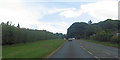
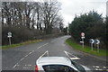
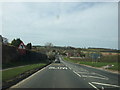
1
A61, Wormald Green
Main road from Ripon to Harrogate
Image: © Chris Heaton
Taken: 2 Aug 2006
0.02 miles
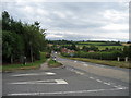
2
The A61 toward Ripley
From the junction with Station Road at Wormald Green
Image: © Martin Dawes
Taken: 10 Nov 2012
0.03 miles
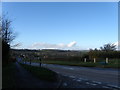
5
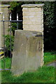
Boundary Stone, Wormald Green
At the junction of Station Road and the A61, marking the boundary between old Ingerthorpe and Bishop Monkton.
Image: © David Rogers
Taken: 3 Apr 2011
0.07 miles
6
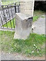
Old Boundary Marker
Parish Boundary Marker on the northeast side of the A61 Ripon Road opposite its junction with Station Road. Was on the boundary of Ingerthorpe and Bishop Monkton parishes, now Markington and Wallerthwaite and Bishop Monkton parishes. Inscribed INGERTHORPE and BISHOP / MONKTON on adjacent faces. See also https://www.geograph.org.uk/photo/2344747.
Milestone Society National ID: YW_MARBMO01pb
Image: © M Hatton
Taken: 3 May 2019
0.07 miles
8

House at Wormald Green
A disused railway cutting was used as a refuse tip but the resultant build up of gas caused an explosion which severely damaged this nearby house at the junction of Station Lane with the A61. The house has been stabilised and the tip is now vented to allow the gases to escape.
Image: © David Rogers
Taken: 18 May 2008
0.08 miles
9
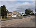
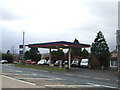
Monkton Moor Garage on Harrogate Road, Wormald Green
Image: © Ian S
Taken: 11 Sep 2020
0.09 miles