IMAGES TAKEN NEAR TO
Markington, HARROGATE, HG3 3PJ
Introduction
This page details the photographs taken nearby to HG3 3PJ by members of the Geograph project.
The Geograph project started in 2005 with the aim of publishing, organising and preserving representative images for every square kilometre of Great Britain, Ireland and the Isle of Man.

There are currently over 7.5m images from over14,400 individuals and you can help contribute to the project by visiting https://www.geograph.org.uk
Image Map (Loading...)


Getting Data...Please wait
Leaflet Map data © OpenStreetMap
Images are licensed for reuse under creativecommons.org/licenses/by-sa/2.0
Notes
- Clicking on the map will re-center to the selected point.
- The higher the marker number, the further away the image location is from the centre of the postcode.
Image Listing (19 Images Found)
Images are licensed for reuse under creativecommons.org/licenses/by-sa/2.0
Image
Details
Distance
3
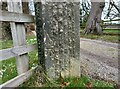
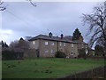
Markington, Holly House
The left hand gate post at the driveway entrance has a benchmark cut into its face.
Image: © Mel Towler
Taken: 2 Feb 2022
0.09 miles
4
Markington, Holly House
The left hand gate post at the driveway entrance to Holly House has a benchmark cut into its face.
Image: © Mel Towler
Taken: 2 Feb 2022
0.09 miles
5
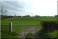
Field and bridleway near Dole Bank
The bridleway heads towards High Cayton.
Image: © DS Pugh
Taken: 16 Apr 2022
0.09 miles
6
![Dry Valley [2]](https://s1.geograph.org.uk/photos/72/43/724369_500d0377_120x120.jpg)
Dry Valley [2]
A little further down the valley is a marshy area and the beginnings of Cayton Beck. The valley is also one of a series of glacial overflow channels which are a feature of the country to the west of Ripon.
Image: © Gordon Hatton
Taken: 13 Mar 2008
0.10 miles
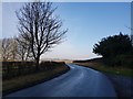
7
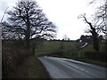
Dam Lane
Between Markington and Bishop Thornton.
Image: © DS Pugh
Taken: 27 Dec 2015
0.12 miles
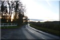
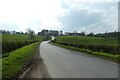
8
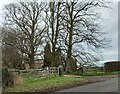
Road by the entrance to Hob Green Hotel
Looking along the road beside the entrance to the hotel.
Image: © DS Pugh
Taken: 1 Jan 2020
0.13 miles
9
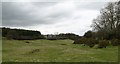
Dry valley near Markington
This dry valley runs roughly SSE from near Haddockstones Grange towards Ripley. About 300m up valley from this view is the point where the original stream has been captured by the stronger Markington Beck, which flows north eastwards.
Image: © Gordon Hatton
Taken: 13 Mar 2008
0.13 miles
10
Dole Bank
Looking up Dole Bank which leads to the Drovers Crossroads.
Image: © DS Pugh
Taken: 16 Apr 2022
0.17 miles