IMAGES TAKEN NEAR TO
Brimham Rocks Road, HARROGATE, HG3 3HF
Introduction
This page details the photographs taken nearby to Brimham Rocks Road, HG3 3HF by members of the Geograph project.
The Geograph project started in 2005 with the aim of publishing, organising and preserving representative images for every square kilometre of Great Britain, Ireland and the Isle of Man.

There are currently over 7.5m images from over14,400 individuals and you can help contribute to the project by visiting https://www.geograph.org.uk
Image Map (Loading...)


Getting Data...Please wait
Leaflet Map data © OpenStreetMap
Images are licensed for reuse under creativecommons.org/licenses/by-sa/2.0
Notes
- Clicking on the map will re-center to the selected point.
- The higher the marker number, the further away the image location is from the centre of the postcode.
Image Listing (15 Images Found)
Images are licensed for reuse under creativecommons.org/licenses/by-sa/2.0
Image
Details
Distance
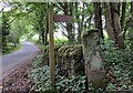
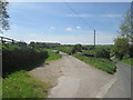
3
The valley of Lurk Beck
The only thing lurking in this small valley is a rather decrepit barn. The beck flows into Thornton Beck, then on downstream to Ripley Castle lake before joining the Nidd.
Image: © Gordon Hatton
Taken: 8 Jan 2014
0.12 miles
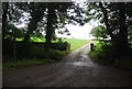
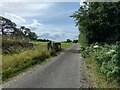
4
Burnt Yates to Brimham Rocks road
The start of the footpath from here to Hartwith. The old gatepost at the beginning of the path has a very clear benchmark about 1 foot from the base.
Image: © Mel Towler
Taken: 14 Jun 2021
0.14 miles
5
Burnt Yates to Brimham Rocks road
The start of the footpath from here to Hartwith, is opposite the entrance to Mansion House Farm. The old gatepost at the beginning of the path has a very clear benchmark about 1 foot from the base.
Image: © Mel Towler
Taken: 14 Jun 2021
0.14 miles
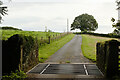
6
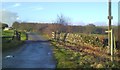
Spring House Farm entrance
The farm road is also a public footpath heading past Spring House Farm to Hartwith.
Image: © Gordon Hatton
Taken: 8 Jan 2014
0.19 miles
8
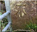
Burnt Yates, Spring House Farm
The benchmark is cut into a gatepost at the entrance to Spring House Farm which is located on the west side of Brimham Rocks Road.
Image: © Mel Towler
Taken: 1 Aug 2022
0.19 miles
9
Burnt Yates, Spring House Farm
There is a benchmark cut into a gatepost at the entrance to Spring House Farm . The farm is located on the west side of Brimham Rocks Road.
Image: © Mel Towler
Taken: 1 Aug 2022
0.19 miles
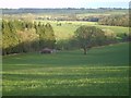
10

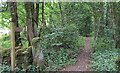
High Eppage Wood
Shaped a bit like a boomerang, pleasant stretch of woodland edging down towards Thornton Beck, a tributary of the River Nidd
Image: © Chris Heaton
Taken: 8 Nov 2006
0.21 miles