IMAGES TAKEN NEAR TO
Pye Lane, HARROGATE, HG3 3EH
Introduction
This page details the photographs taken nearby to Pye Lane, HG3 3EH by members of the Geograph project.
The Geograph project started in 2005 with the aim of publishing, organising and preserving representative images for every square kilometre of Great Britain, Ireland and the Isle of Man.

There are currently over 7.5m images from over14,400 individuals and you can help contribute to the project by visiting https://www.geograph.org.uk
Image Map
Images are licensed for reuse under creativecommons.org/licenses/by-sa/2.0
Notes
- Clicking on the map will re-center to the selected point.
- The higher the marker number, the further away the image location is from the centre of the postcode.
Image Listing (9 Images Found)
Images are licensed for reuse under creativecommons.org/licenses/by-sa/2.0
Image
Details
Distance

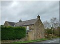
2
Shaw Mills, Fairvew
The benchmark is cut into the east face of the property.
Image: © Mel Towler
Taken: 16 Mar 2023
0.07 miles
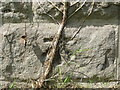
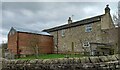
3
Shaw Mills, Fairview
There is a benchmark cut into the east face of the property, which is the gable end facing onto the road.
Image: © Mel Towler
Taken: 16 Mar 2023
0.07 miles
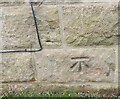
4
Ordnance Survey Cut Mark
This mark can be found on the roadside wall of Fairview in Pye Lane, Burnt Yates. The calculated benchmark height is recorded as being 121.883 metres above sea level. For more detail see : http://www.bench-marks.org.uk/bm90555
Image: © Peter Wood
Taken: 7 Aug 2017
0.08 miles
5
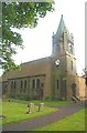
Burnt Yates, St Andrew's Church
This Church is in the south western corner of the O/S grid it occupies
Image: © Bill Henderson
Taken: Unknown
0.11 miles
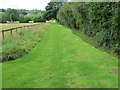
6
Shaw Mills, Rose Lea Farm
According to the OS benchmark database there is a benchmark cut into the north facing wall of the property. The chicken coop obscures any view from the roadside.
Image: © Mel Towler
Taken: 16 Mar 2023
0.13 miles
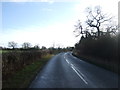
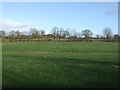
8
Enclosed Footpath and Bridleway from Hill Top to Pye Lane
Looking westward.
Image: © Peter Wood
Taken: 7 Aug 2017
0.16 miles