IMAGES TAKEN NEAR TO
Cornel Rise, HARROGATE, HG3 2XX
Introduction
This page details the photographs taken nearby to Cornel Rise, HG3 2XX by members of the Geograph project.
The Geograph project started in 2005 with the aim of publishing, organising and preserving representative images for every square kilometre of Great Britain, Ireland and the Isle of Man.

There are currently over 7.5m images from over14,400 individuals and you can help contribute to the project by visiting https://www.geograph.org.uk
Image Map
Images are licensed for reuse under creativecommons.org/licenses/by-sa/2.0
Notes
- Clicking on the map will re-center to the selected point.
- The higher the marker number, the further away the image location is from the centre of the postcode.
Image Listing (12 Images Found)
Images are licensed for reuse under creativecommons.org/licenses/by-sa/2.0
Image
Details
Distance
2
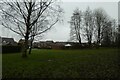
Grassy area near Saltergate Drive
Looking towards Saltergate Drive in Jennyfield.
Image: © DS Pugh
Taken: 29 Dec 2021
0.14 miles
3
Sallow Heath
Looking along Sallow Heath from Sweet Briar.
Image: © DS Pugh
Taken: 29 Dec 2021
0.15 miles
4
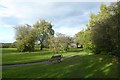
Bench near Killinghall Moor
A bench on the southern edge of Jennyfield.
Image: © DS Pugh
Taken: 7 Oct 2017
0.17 miles
5
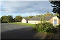
Building at Killinghall Moor Country Park
A sports building at Killinghall Moor.
Image: © DS Pugh
Taken: 7 Oct 2017
0.17 miles
6
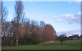
Public open space, Jennyfield
Open area to the east of Crowberry Drive on the Jennyfield estate, Harrogate.
Image: © Gordon Hatton
Taken: 1 Feb 2012
0.18 miles
7
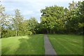
Path near Sweet Briar
Path from Killinghall Moor near Sweet Briar in Jennyfield.
Image: © DS Pugh
Taken: 7 Oct 2017
0.18 miles
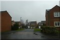
8

Sweet Briar
Looking along a street of housing on the southern extent of Jennyfield.
Image: © DS Pugh
Taken: 7 Oct 2017
0.19 miles
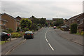
9
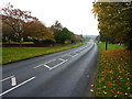
Jennyfield Drive, looking west
A damp morning in northwest Harrogate
Image: © Richard Law
Taken: 24 Oct 2019
0.19 miles
10
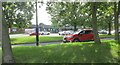
Shops at Jennyfield
Harrogate ringway
Image: © steven ruffles
Taken: 20 Aug 2023
0.21 miles