IMAGES TAKEN NEAR TO
Buttercup Close, HARROGATE, HG3 2WU
Introduction
This page details the photographs taken nearby to Buttercup Close, HG3 2WU by members of the Geograph project.
The Geograph project started in 2005 with the aim of publishing, organising and preserving representative images for every square kilometre of Great Britain, Ireland and the Isle of Man.

There are currently over 7.5m images from over14,400 individuals and you can help contribute to the project by visiting https://www.geograph.org.uk
Image Map (Loading...)


Getting Data...Please wait
Leaflet Map data © OpenStreetMap
Images are licensed for reuse under creativecommons.org/licenses/by-sa/2.0
Notes
- Clicking on the map will re-center to the selected point.
- The higher the marker number, the further away the image location is from the centre of the postcode.
Image Listing (4 Images Found)
Images are licensed for reuse under creativecommons.org/licenses/by-sa/2.0
Image
Details
Distance
1
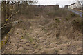
Oaker Bank Bridge
The bridge is now disused and very overgrown. There is a cut bench mark on the parapet to the right of the photograph but I was unable to find it on this occasion. Bench Mark Database: http://www.bench-marks.org.uk/bm47413
Image: © Mark Anderson
Taken: 26 Feb 2013
0.22 miles
2
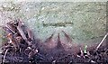
Harrogate, Oaker Bank Bridge
The benchmark is cut into the eastern parapet of the by-passed Oaker Bank Bridge.
Image: © Mel Towler
Taken: 22 Mar 2023
0.22 miles
3
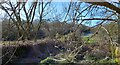
Harrogate, Oaker Bank Bridge
There is a benchmark cut into the eastern parapet of the by-passed Oaker Bank Bridge.
Image: © Mel Towler
Taken: 22 Mar 2023
0.22 miles
4
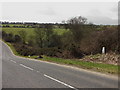
Oaker Bank
Just visible in the middle distance is the parapet of Oaker Bank Bridge which once carried the Dudley Hill Killinghall & Harrogate Road (according to the nearby milepost) over Saltergate Beck.
Image: © David Rogers
Taken: 8 Apr 2010
0.22 miles