IMAGES TAKEN NEAR TO
Menwith Hill, HARROGATE, HG3 2RF
Introduction
This page details the photographs taken nearby to HG3 2RF by members of the Geograph project.
The Geograph project started in 2005 with the aim of publishing, organising and preserving representative images for every square kilometre of Great Britain, Ireland and the Isle of Man.

There are currently over 7.5m images from over14,400 individuals and you can help contribute to the project by visiting https://www.geograph.org.uk
Image Map (Loading...)


Getting Data...Please wait
Leaflet Map data © OpenStreetMap
Images are licensed for reuse under creativecommons.org/licenses/by-sa/2.0
Notes
- Clicking on the map will re-center to the selected point.
- The higher the marker number, the further away the image location is from the centre of the postcode.
Image Listing (6 Images Found)
Images are licensed for reuse under creativecommons.org/licenses/by-sa/2.0
Image
Details
Distance
1
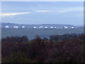
RAF Menwith Hill From Brimham Rocks
Taken looking South from Brimham Rocks.
Image: © Keith Laverack
Taken: 2 Apr 2008
0.13 miles
2
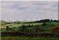
RAF Menwith Hill Monitoring Station
Image: © Gordon Kneale Brooke
Taken: 9 Jul 2002
0.18 miles
3

Menwith Hill from Foldshaw Lane
Looking across Thornthwaite towards Menwith Hill camp.
Image: © DS Pugh
Taken: 1 Apr 2013
0.18 miles

5
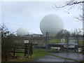
Radome, RAF Menwith Hill Monitoring Station
A blocked entrance and radomes behind.
Image: © JThomas
Taken: 10 Dec 2016
0.19 miles
6
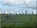
Radomes - Menwith Hill Camp
No problems with the military police whilst taking this picture (see Image - some people just attract attention!), but a bit of traffic-dodging was required on the very busy A59.
Image: © Richard Law
Taken: 10 May 2011
0.22 miles