IMAGES TAKEN NEAR TO
Southview, HARROGATE, HG3 2PT
Introduction
This page details the photographs taken nearby to Southview, HG3 2PT by members of the Geograph project.
The Geograph project started in 2005 with the aim of publishing, organising and preserving representative images for every square kilometre of Great Britain, Ireland and the Isle of Man.

There are currently over 7.5m images from over14,400 individuals and you can help contribute to the project by visiting https://www.geograph.org.uk
Image Map
Images are licensed for reuse under creativecommons.org/licenses/by-sa/2.0
Notes
- Clicking on the map will re-center to the selected point.
- The higher the marker number, the further away the image location is from the centre of the postcode.
Image Listing (44 Images Found)
Images are licensed for reuse under creativecommons.org/licenses/by-sa/2.0
Image
Details
Distance
2
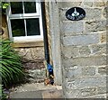
Darley, 1 Nidd Lane
The cottage is at the eastern end of Darley village, and is located on the western side of the bridlepath which runs down to the River Nidd, crosses the river and northwards to Birchfield Farm. This benchmark is on the front of the cottage on an east facing wall and about 2 foot from ground level.
Image: © Mel Towler
Taken: 23 Jul 2021
0.01 miles
3
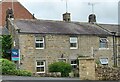
Darley, 1 Nidd Lane
A wider angle showing No 1 Nidd Lane, a cottage at the eastern end of Darley village, and it is located on the western side of the bridlepath which runs down to the River Nidd, crosses the river and northwards to Birchfield Farm. There is a benchmark on the front of the cottage, on a left cornerstone on this east facing wall and it is about 2 foot from ground level.
Image: © Mel Towler
Taken: 23 Jul 2021
0.01 miles
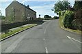
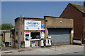
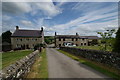
6
Main Street, Darley
Taken from the bus stop at the junction with Nidd Lane.
Image: © Mark Anderson
Taken: 28 May 2018
0.05 miles
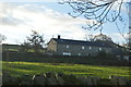
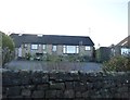
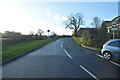
10
Southfield Farm
The farmhouse on the left is Grade II listed, https://www.historicengland.org.uk/listing/the-list/list-entry/1251458 , and dates from the mid-eighteenth century. Two former farm-hand cottages on the right were converted in 1986/7 to two holiday cottages. I've stayed here five times between 1987 and 2011. The farm had closed down its dairy herd since I last came here in 1995, and the farmer and his wife were retired - sort of!
Curious about the name as the buildings lie on the North side of the road; never though of asking the owners the origin of the name!
Image: © John Webb
Taken: 6 Jun 2011
0.10 miles