IMAGES TAKEN NEAR TO
HG3 2NY
Introduction
This page details the photographs taken nearby to HG3 2NY by members of the Geograph project.
The Geograph project started in 2005 with the aim of publishing, organising and preserving representative images for every square kilometre of Great Britain, Ireland and the Isle of Man.

There are currently over 7.5m images from over14,400 individuals and you can help contribute to the project by visiting https://www.geograph.org.uk
Image Map (Loading...)


Getting Data...Please wait
Leaflet Map data © OpenStreetMap
Images are licensed for reuse under creativecommons.org/licenses/by-sa/2.0
Notes
- Clicking on the map will re-center to the selected point.
- The higher the marker number, the further away the image location is from the centre of the postcode.
Image Listing (3 Images Found)
Images are licensed for reuse under creativecommons.org/licenses/by-sa/2.0
Image
Details
Distance
1
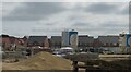
Ever expanding Harrogate
Another new area of residential building on the west side of Harrogate adjacent to the B6161. One only has to go a little further north on the far side of the A59 to see similar development, whilst the same is occurring along the B6162 between Harlow Hill and Beckwithshaw.
Image: © Gordon Hatton
Taken: 2 Sep 2021
0.19 miles
2
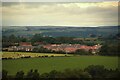
Housing development at Oakdale, Harrogate
Looking across farmland towards a modern housing development off Penny Pot Lane on the edge of Harrogate.
Image: © Graham Robson
Taken: 17 Jul 2020
0.24 miles
3
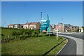
King Edwin Park
A new housing development to the north of Penny Pot Lane.
Image: © DS Pugh
Taken: 3 Jun 2023
0.25 miles