IMAGES TAKEN NEAR TO
The Allotments, HARROGATE, HG3 2NQ
Introduction
This page details the photographs taken nearby to The Allotments, HG3 2NQ by members of the Geograph project.
The Geograph project started in 2005 with the aim of publishing, organising and preserving representative images for every square kilometre of Great Britain, Ireland and the Isle of Man.

There are currently over 7.5m images from over14,400 individuals and you can help contribute to the project by visiting https://www.geograph.org.uk
Image Map
Images are licensed for reuse under creativecommons.org/licenses/by-sa/2.0
Notes
- Clicking on the map will re-center to the selected point.
- The higher the marker number, the further away the image location is from the centre of the postcode.
Image Listing (47 Images Found)
Images are licensed for reuse under creativecommons.org/licenses/by-sa/2.0
Image
Details
Distance
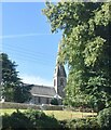
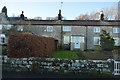
1
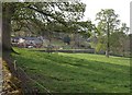
Houses on Darley Road, Birstwith
Seen across a meadow. This is close to Image
Image: © Derek Harper
Taken: 13 Apr 2009
0.04 miles
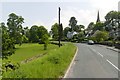
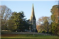
5
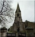
Down Lackon Bank
Looking towards St. James' Church.
Image: © DS Pugh
Taken: 28 Mar 2021
0.06 miles
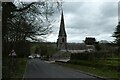
6
Birstwith, St James' church
The benchmark is cut the north-west face of the church tower.
Image: © Mel Towler
Taken: 21 Nov 2022
0.06 miles
7
Birstwith, St James' church
There is a benchmark cut the north-west face of the church tower.
Image: © Mel Towler
Taken: 21 Nov 2022
0.06 miles
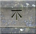
8
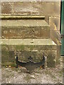
Birstwith Bench Mark
Cut mark located on St James' Church Tower; height 99.392m, last verified 1975.
Image: © David Rogers
Taken: 17 Sep 2010
0.06 miles