IMAGES TAKEN NEAR TO
The Square, HARROGATE, HG3 2NL
Introduction
This page details the photographs taken nearby to The Square, HG3 2NL by members of the Geograph project.
The Geograph project started in 2005 with the aim of publishing, organising and preserving representative images for every square kilometre of Great Britain, Ireland and the Isle of Man.

There are currently over 7.5m images from over14,400 individuals and you can help contribute to the project by visiting https://www.geograph.org.uk
Image Map
Images are licensed for reuse under creativecommons.org/licenses/by-sa/2.0
Notes
- Clicking on the map will re-center to the selected point.
- The higher the marker number, the further away the image location is from the centre of the postcode.
Image Listing (78 Images Found)
Images are licensed for reuse under creativecommons.org/licenses/by-sa/2.0
Image
Details
Distance
2
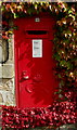
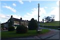
GR Postbox, Birstwith
Box number HG3 181, in the wall of Cob Cottage next to The Dale Stores and village Post Office.
Image: © David Rogers
Taken: 17 Sep 2010
0.02 miles
4
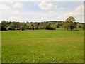
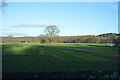
Over fields to Birstwith from the Nidderdale Way
Image: © Martin Dawes
Taken: 5 May 2016
0.05 miles
5
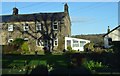
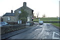
Towards Birstwith Post Office
Looking across to The Dale Stores, the former post office building in Birstwith.
Image: © DS Pugh
Taken: 29 Dec 2015
0.05 miles
6

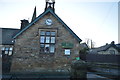
The Dale Stores & Post Office, Birstwith
Viewed from St James' Churchyard.
Image: © David Rogers
Taken: 17 Sep 2010
0.05 miles
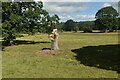
9
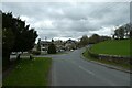
Birstwith
Looking along Darley Road towards the village.
Image: © DS Pugh
Taken: 28 Mar 2021
0.06 miles