IMAGES TAKEN NEAR TO
Skipton Road, HARROGATE, HG3 2LZ
Introduction
This page details the photographs taken nearby to Skipton Road, HG3 2LZ by members of the Geograph project.
The Geograph project started in 2005 with the aim of publishing, organising and preserving representative images for every square kilometre of Great Britain, Ireland and the Isle of Man.

There are currently over 7.5m images from over14,400 individuals and you can help contribute to the project by visiting https://www.geograph.org.uk
Image Map (Loading...)


Getting Data...Please wait
Leaflet Map data © OpenStreetMap
Images are licensed for reuse under creativecommons.org/licenses/by-sa/2.0
Notes
- Clicking on the map will re-center to the selected point.
- The higher the marker number, the further away the image location is from the centre of the postcode.
Image Listing (5 Images Found)
Images are licensed for reuse under creativecommons.org/licenses/by-sa/2.0
Image
Details
Distance
1
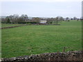
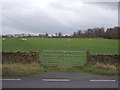
Grazing towards Gill Thorn Farm
North of Skipton Road (A59).
Image: © JThomas
Taken: 10 Dec 2016
0.08 miles
2
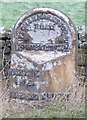
Old Milestone by the A59, Skipton Road, Hampsthwaite
Metal plate attached to stone post by the A59, in parish of HAMPSTHWAITE (HARROGATE District), Skipton Road; East of entrance to Gill Thorn Grange, by the road, on North side of road. WR iron casting, erected by the County Council in the 19th century.
Inscription reads:-
: HARROGATE / 4 MILES / KNARESBORO / 6¾ MILES : : SKIPTON & KNARESBOROUGH / ROAD / HAMPSTHWAITE : : SKIPTON / 18 MILES :
Carved benchmark and rivet on top.
Grade II listed.
List Entry Number: 1173570 https://historicengland.org.uk/listing/the-list/list-entry/1173570
Milestone Society National ID: YN_SKKB18
Image: © C Minto
Taken: 16 May 2004
0.14 miles
3
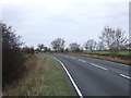
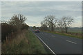
Skipton Road (A59)
Looking north east - direction Harrogate.
Image: © JThomas
Taken: 10 Dec 2016
0.14 miles