IMAGES TAKEN NEAR TO
Long Lane, HARROGATE, HG3 2LU
Introduction
This page details the photographs taken nearby to Long Lane, HG3 2LU by members of the Geograph project.
The Geograph project started in 2005 with the aim of publishing, organising and preserving representative images for every square kilometre of Great Britain, Ireland and the Isle of Man.

There are currently over 7.5m images from over14,400 individuals and you can help contribute to the project by visiting https://www.geograph.org.uk
Image Map (Loading...)


Getting Data...Please wait
Leaflet Map data © OpenStreetMap
Images are licensed for reuse under creativecommons.org/licenses/by-sa/2.0
Notes
- Clicking on the map will re-center to the selected point.
- The higher the marker number, the further away the image location is from the centre of the postcode.
Image Listing (8 Images Found)
Images are licensed for reuse under creativecommons.org/licenses/by-sa/2.0
Image
Details
Distance
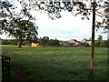
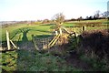
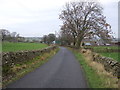
1
Long Lane
Looking north west near Croft House Farm.
Image: © JThomas
Taken: 10 Dec 2016
0.03 miles
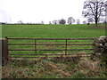
2
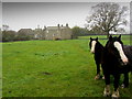
Pond House Farm
Large farming operation at the end of Long Lane, just north of the A59.
Image: © Chris Heaton
Taken: 24 Oct 2012
0.05 miles
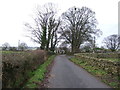
7
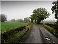
Long Lane (North)
Misty outlook along the access lane to Pond House Farm from the A59.
Image: © Chris Heaton
Taken: 24 Oct 2012
0.20 miles