IMAGES TAKEN NEAR TO
Swincliffe Top, HARROGATE, HG3 2HY
Introduction
This page details the photographs taken nearby to Swincliffe Top, HG3 2HY by members of the Geograph project.
The Geograph project started in 2005 with the aim of publishing, organising and preserving representative images for every square kilometre of Great Britain, Ireland and the Isle of Man.

There are currently over 7.5m images from over14,400 individuals and you can help contribute to the project by visiting https://www.geograph.org.uk
Image Map
Images are licensed for reuse under creativecommons.org/licenses/by-sa/2.0
Notes
- Clicking on the map will re-center to the selected point.
- The higher the marker number, the further away the image location is from the centre of the postcode.
Image Listing (16 Images Found)
Images are licensed for reuse under creativecommons.org/licenses/by-sa/2.0
Image
Details
Distance
1
Birstwith, old Laundry House
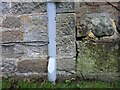
The benchmark is cut into a cornerstone of a stone built add on to the main house.
Image: © Mel Towler
Taken: 22 Dec 2021
0.01 miles
2
Birstwith, old Laundry House
There is a benchmark cut into a cornerstone of a stone built add on to the main house.
Image: © Mel Towler
Taken: 22 Dec 2021
0.01 miles
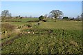
3
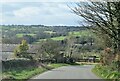
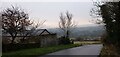
Down the hill at Swincliffe Side
An area of pastures and woodland to the west of Harrogate where the hills rise towards the Pennines.
Image: © Gordon Hatton
Taken: 21 Mar 2021
0.05 miles
4
Swincliffe, outbuilding
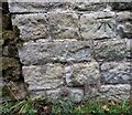
The benchmark is cut into the roadside wall of a stone built farm outbuilding.
Image: © Mel Towler
Taken: 22 Dec 2021
0.07 miles
5
Swincliffe, outbuilding
There is a benchmark cut into the roadside wall of this stone built farm outbuilding.
Image: © Mel Towler
Taken: 22 Dec 2021
0.07 miles
6
Swincliffe Pound
Hidden by a mass of summer vegetation, this small circular walled enclosure was for the detention of any beasts that were found beyond the Common Land of the Parish and a toll would have to be paid by the owner to release their stock.
Image: © Matthew Hatton
Taken: 20 Jun 2021
0.10 miles
7
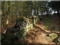
Wall in Gormires Wood
The footpath from Hirst Lane to Swincliffe climbs past this stone wall and a conifer plantation in the upper part of the wood.
Image: © Derek Harper
Taken: 13 Apr 2009
0.13 miles
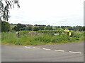
9
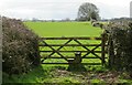
A curious stile
Heading across a field on footpath number 15.39/16 one is aware of a gate in the far corner, but as one approaches it becomes clear that the gate has been modified as a fence and a timber step stile constructed to get over it. Very odd.
Image: © Gordon Hatton
Taken: 21 Mar 2021
0.17 miles
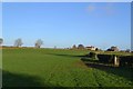
10
Footpath near Swincliffe
This path connects Swincliffe with Horsemans Well Farm
Image: © John Sparshatt
Taken: 9 Jan 2013
0.19 miles