IMAGES TAKEN NEAR TO
Spruisty Green, HARROGATE, HG3 2FG
Introduction
This page details the photographs taken nearby to Spruisty Green, HG3 2FG by members of the Geograph project.
The Geograph project started in 2005 with the aim of publishing, organising and preserving representative images for every square kilometre of Great Britain, Ireland and the Isle of Man.

There are currently over 7.5m images from over14,400 individuals and you can help contribute to the project by visiting https://www.geograph.org.uk
Image Map (53 Images)


Getting Data...Please wait
Leaflet Map data © OpenStreetMap
Images are licensed for reuse under creativecommons.org/licenses/by-sa/2.0
Notes
- Clicking on the map will re-center to the selected point.
- The higher the marker number, the further away the image location is from the centre of the postcode.
Image Listing (53 Images Found)
Images are licensed for reuse under creativecommons.org/licenses/by-sa/2.0
Image
Details
Distance
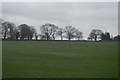
1
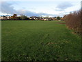
Footpath leading to Killinghall
The path although not evident on the ground, runs beside the hedge towards Killinghall.
Image: © Chris Heaton
Taken: 29 Nov 2013
0.03 miles
4
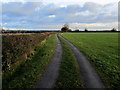
Access Lane to Spruisty Grange Farm
Access lane leading from the A61.
Image: © Chris Heaton
Taken: 29 Nov 2013
0.08 miles
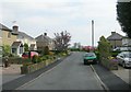
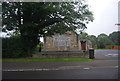
5
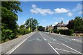
Ripon Road
CAV is for Mark Cavendish. The road was closed for the Tour de France Stage 1 (Leeds to Harrogate). Children were being given chalk to decorate the roads.
Image: © DS Pugh
Taken: 5 Jul 2014
0.09 miles
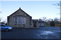
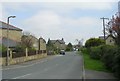
10
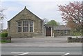
Killinghall Methodist Church - Ripon Road
Image: © Betty Longbottom
Taken: 18 Apr 2009
0.12 miles