IMAGES TAKEN NEAR TO
Castle Road, HARROGATE, HG3 2DU
Introduction
This page details the photographs taken nearby to Castle Road, HG3 2DU by members of the Geograph project.
The Geograph project started in 2005 with the aim of publishing, organising and preserving representative images for every square kilometre of Great Britain, Ireland and the Isle of Man.

There are currently over 7.5m images from over14,400 individuals and you can help contribute to the project by visiting https://www.geograph.org.uk
Image Map (Loading...)


Getting Data...Please wait
Leaflet Map data © OpenStreetMap
Images are licensed for reuse under creativecommons.org/licenses/by-sa/2.0
Notes
- Clicking on the map will re-center to the selected point.
- The higher the marker number, the further away the image location is from the centre of the postcode.
Image Listing (63 Images Found)
Images are licensed for reuse under creativecommons.org/licenses/by-sa/2.0
Image
Details
Distance
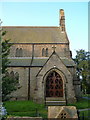
4
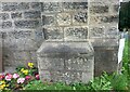
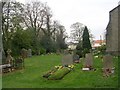
Killinghall, St Thomas's church
This is the west facing wall of the front of the church. The benchmark is cut into the right buttress of the front facia.
Image: © Mel Towler
Taken: 5 Sep 2021
0.05 miles
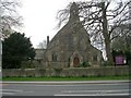
6
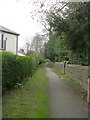
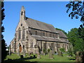
St. Thomas the Apostle church, Killinghall
A late nineteenth century church, seen from the Church Lane footpath.
Image: © Derek Harper
Taken: 29 Jun 2006
0.06 miles
7
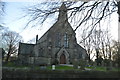
St Thomas the Apostle - Otley Road
Image: © Betty Longbottom
Taken: 18 Apr 2009
0.06 miles