IMAGES TAKEN NEAR TO
Skipton Road, HARROGATE, HG3 2BU
Introduction
This page details the photographs taken nearby to Skipton Road, HG3 2BU by members of the Geograph project.
The Geograph project started in 2005 with the aim of publishing, organising and preserving representative images for every square kilometre of Great Britain, Ireland and the Isle of Man.

There are currently over 7.5m images from over14,400 individuals and you can help contribute to the project by visiting https://www.geograph.org.uk
Image Map (Loading...)


Getting Data...Please wait
Leaflet Map data © OpenStreetMap
Images are licensed for reuse under creativecommons.org/licenses/by-sa/2.0
Notes
- Clicking on the map will re-center to the selected point.
- The higher the marker number, the further away the image location is from the centre of the postcode.
Image Listing (16 Images Found)
Images are licensed for reuse under creativecommons.org/licenses/by-sa/2.0
Image
Details
Distance
4
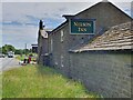
Nelson inn, Skipton Road, Harrogate
The Nelson Inn pub located on the main Skipton Road leading into Harrogate. The building also has an Ordnance Survey bench mark.
Image
Image: © V1ncenze
Taken: 15 Jun 2021
0.08 miles
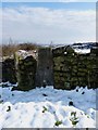
5
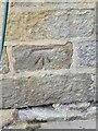
Ordnance Survey Bench mark
This mark is located on the wall at the Nelson Inn Pub, Skipton Road, Harrogate. These marks were used by Ordnance Survey for mapping purposes.
Image
Image: © V1ncenze
Taken: 15 Jun 2021
0.08 miles
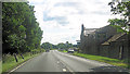
6
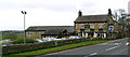
Nelson Inn
Beside A59 at Saltergate above Harrogate.
Image: © David Rogers
Taken: 22 Mar 2009
0.08 miles
7
Nelson Inn Skipton Road
The present owners who came in 2021 have no photos of the inn beyond 20 years and would like to hear from anyone with a photo or has memories of the inn in the 1900's.
Image: © Martin Dawes
Taken: 4 Sep 2023
0.09 miles
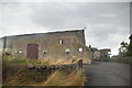
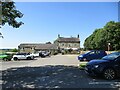
8
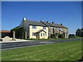
Cottages alongside the A59 at Saltergate Hill
Opposite the Nelson Inn, this photo taken over car park wall
Image: © Martin Dawes
Taken: 4 Sep 2023
0.10 miles
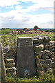
9
Mount Pleasant trig
A conventional concrete trig, TP4949 sporting flush bracket S7749, built into a drystone wall that runs across Mount Pleasant hill.
Image: © Richard Law
Taken: 19 Mar 2013
0.15 miles
10
Mount Pleasant Trig
A closer view of the flush bracket can be seen here: Image
Image: © Mark Anderson
Taken: 30 Jul 2013
0.15 miles