IMAGES TAKEN NEAR TO
Crag Lane, HARROGATE, HG3 2BB
Introduction
This page details the photographs taken nearby to Crag Lane, HG3 2BB by members of the Geograph project.
The Geograph project started in 2005 with the aim of publishing, organising and preserving representative images for every square kilometre of Great Britain, Ireland and the Isle of Man.

There are currently over 7.5m images from over14,400 individuals and you can help contribute to the project by visiting https://www.geograph.org.uk
Image Map (Loading...)


Getting Data...Please wait
Leaflet Map data © OpenStreetMap
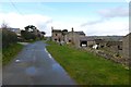
Images are licensed for reuse under creativecommons.org/licenses/by-sa/2.0
Notes
- Clicking on the map will re-center to the selected point.
- The higher the marker number, the further away the image location is from the centre of the postcode.
Image Listing (20 Images Found)
Images are licensed for reuse under creativecommons.org/licenses/by-sa/2.0
Image
Details
Distance
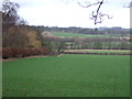
5
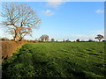
Field near Crag Hill
Countryside to the west of Killinghall
Image: © Chris Heaton
Taken: 29 Nov 2013
0.08 miles
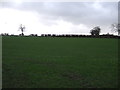
7
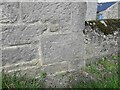
Crag Hill Farm, Killinghall - benchmark
condition is good, easy to spot
Image: © Mel Towler
Taken: 11 Apr 2021
0.10 miles

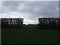
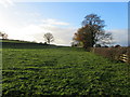
9
Crag Hill
Looking down the track from Myers Green, Crag Hill Farm on the left, Ash Farm on the right.
Image: © manonabike
Taken: 11 Sep 2006
0.12 miles
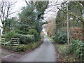
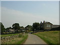
10
Crag Hill Farm
Looking along Crag Hill Lane and the bridleway through to Myer's Green Lane.
Image: © DS Pugh
Taken: 22 Feb 2014
0.14 miles