IMAGES TAKEN NEAR TO
Ripon Road, HARROGATE, HG3 2AT
Introduction
This page details the photographs taken nearby to Ripon Road, HG3 2AT by members of the Geograph project.
The Geograph project started in 2005 with the aim of publishing, organising and preserving representative images for every square kilometre of Great Britain, Ireland and the Isle of Man.

There are currently over 7.5m images from over14,400 individuals and you can help contribute to the project by visiting https://www.geograph.org.uk
Image Map
Images are licensed for reuse under creativecommons.org/licenses/by-sa/2.0
Notes
- Clicking on the map will re-center to the selected point.
- The higher the marker number, the further away the image location is from the centre of the postcode.
Image Listing (36 Images Found)
Images are licensed for reuse under creativecommons.org/licenses/by-sa/2.0
Image
Details
Distance

6
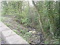
Grain Beck - viewed from Grainbeck Lane Bridge
Image: © Betty Longbottom
Taken: 18 Apr 2009
0.12 miles
8
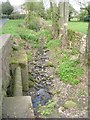
Grain Beck - viewed from Grainbeck Lane Bridge
Image: © Betty Longbottom
Taken: 18 Apr 2009
0.12 miles
9
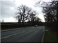
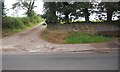
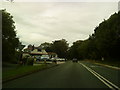
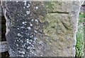
Killinghall, A61
There is a benchmark cut into the left field gatepost on the west side of A61 as approach Killinghall from Harrogate.
Image: © Mel Towler
Taken: 18 Dec 2022
0.12 miles
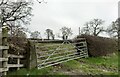
10
Killinghall, A61
The benchmark is cut into a field gatepost on the west side of A61 as approach Killinghall from Harrogate.
Image: © Mel Towler
Taken: 18 Dec 2022
0.12 miles