IMAGES TAKEN NEAR TO
Knox Mill Close, HARROGATE, HG3 2AG
Introduction
This page details the photographs taken nearby to Knox Mill Close, HG3 2AG by members of the Geograph project.
The Geograph project started in 2005 with the aim of publishing, organising and preserving representative images for every square kilometre of Great Britain, Ireland and the Isle of Man.

There are currently over 7.5m images from over14,400 individuals and you can help contribute to the project by visiting https://www.geograph.org.uk
Image Map
Images are licensed for reuse under creativecommons.org/licenses/by-sa/2.0
Notes
- Clicking on the map will re-center to the selected point.
- The higher the marker number, the further away the image location is from the centre of the postcode.
Image Listing (38 Images Found)
Images are licensed for reuse under creativecommons.org/licenses/by-sa/2.0
Image
Details
Distance
1
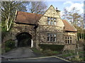
Knox, Knox Mill House
There is a benchmark cut into this east facing wall, between the drainpipe and the window.
Image: © Mel Towler
Taken: 5 Sep 2021
0.08 miles
2
Knox, Knox Mill House
A wider angle showing the east facing wall and gable end of Knox Mill House. There is a benchmark cut into this wall between the drainpipe and the window.
Image: © Mel Towler
Taken: 5 Sep 2021
0.08 miles
3
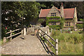
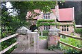
Closed Ford
The ford connecting Knox Mill Lane with Knox Lane has been closed for several years although walkers can still cross Oak Beck using the 17th century Spruisty Bridge. This listed bridge carried packhorse traffic between Knaresborough and Ripley through Bilton, Knox and Killinghall.
Image: © David Rogers
Taken: 13 Jun 2008
0.10 miles
4

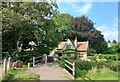
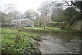
By the Oak Beck, Knox
A view from Spruisty Bridge, with the stream running towards the camera on the left, and a green with trees providing a charming outlook for the houses on Knox Mill Lane.
Image: © Derek Harper
Taken: 1 Apr 2012
0.10 miles
5
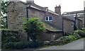
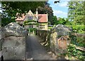
C17 house in the hamlet of Knox, near Knaresborough
Old sundial formerly belonged to ford keeper's cottage, now demolished.
Image: © Allan Friswell
Taken: 7 Feb 2014
0.11 miles
6
Spruisty bridge.
A 17th century listed bridge.
Image: © steven ruffles
Taken: 20 Aug 2023
0.11 miles
7
Knox, Spruisty Bridge
A wider angle looking north along the packhorse bridge. According to the OS database there is a benchmark cut into the eastern parapet and at the south end of the bridge. Nothing could be found.
Image: © Mel Towler
Taken: 5 Sep 2021
0.11 miles
8
Knox, Spruisty Bridge
This is looking north along the packhorse bridge. According to the OS database there is a benchmark cut into the eastern parapet and at the south end of the bridge. Nothing could be found.
Image: © Mel Towler
Taken: 5 Sep 2021
0.11 miles
9
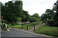
Ford at Knox
This ford on the Oak Beck is found at the end of Knox Mill Lane. The Six Dales Trail passes over the Spruisty packhorse bridge at this point.
Image: © John Walton
Taken: 15 Nov 2014
0.12 miles