IMAGES TAKEN NEAR TO
Haverah Park, HARROGATE, HG3 1TL
Introduction
This page details the photographs taken nearby to Haverah Park, HG3 1TL by members of the Geograph project.
The Geograph project started in 2005 with the aim of publishing, organising and preserving representative images for every square kilometre of Great Britain, Ireland and the Isle of Man.

There are currently over 7.5m images from over14,400 individuals and you can help contribute to the project by visiting https://www.geograph.org.uk
Image Map
Images are licensed for reuse under creativecommons.org/licenses/by-sa/2.0
Notes
- Clicking on the map will re-center to the selected point.
- The higher the marker number, the further away the image location is from the centre of the postcode.
Image Listing (5 Images Found)
Images are licensed for reuse under creativecommons.org/licenses/by-sa/2.0
Image
Details
Distance
1
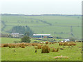
Holen House Farm
Viewed from a public footpath higher up the hill.
Image: © Stephen Craven
Taken: 27 Dec 2019
0.01 miles
2
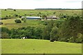
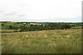
Farmland at Holen House
Looking across the valley of the Oak Beck to Holen House Farm and its surrounding fields.
Image: © Graham Robson
Taken: 17 Jul 2020
0.01 miles
3
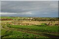
Track to Holen House
The red disc and sign above it make it clear there is no public access along the track.
Image: © DS Pugh
Taken: 30 Dec 2024
0.22 miles
4
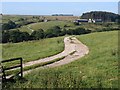
Track to Holen House
The track leaves footpath 15 56/7/1 and crosses the Oak Beck valley to Holen House.
Image: © Derek Harper
Taken: 28 Jul 2011
0.23 miles
5
Grassland above Holen House Farm
Rough grassland on the hill above Holen House Farm.
Image: © Graham Robson
Taken: 17 Jul 2020
0.23 miles