IMAGES TAKEN NEAR TO
Fewston, HARROGATE, HG3 1SW
Introduction
This page details the photographs taken nearby to HG3 1SW by members of the Geograph project.
The Geograph project started in 2005 with the aim of publishing, organising and preserving representative images for every square kilometre of Great Britain, Ireland and the Isle of Man.

There are currently over 7.5m images from over14,400 individuals and you can help contribute to the project by visiting https://www.geograph.org.uk
Image Map (Loading...)


Getting Data...Please wait
Leaflet Map data © OpenStreetMap
Images are licensed for reuse under creativecommons.org/licenses/by-sa/2.0
Notes
- Clicking on the map will re-center to the selected point.
- The higher the marker number, the further away the image location is from the centre of the postcode.
Image Listing (5 Images Found)
Images are licensed for reuse under creativecommons.org/licenses/by-sa/2.0
Image
Details
Distance
1
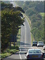
Roman Road
This part of the A59 is noted on the maps as a Roman Road. I hope they had good brakes on their chariots and strong horses! Drive it in a car and it's like the dips on a rollercoaster.
Image: © Malcolm Street
Taken: 22 Sep 2005
0.03 miles
3
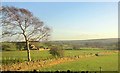
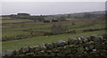
Spring Hills
Spring Hills is the farm behind the tree.View from the Skipton Road close to Watling Street House.
Image: © Derek Harper
Taken: 29 Dec 2013
0.08 miles
5
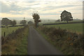
Ruined farm building from Spinksburn Lane
Image: © Peter Bond
Taken: 25 Feb 2013
0.20 miles