IMAGES TAKEN NEAR TO
Briscoe Ridge Lane, HARROGATE, HG3 1FB
Introduction
This page details the photographs taken nearby to Briscoe Ridge Lane, HG3 1FB by members of the Geograph project.
The Geograph project started in 2005 with the aim of publishing, organising and preserving representative images for every square kilometre of Great Britain, Ireland and the Isle of Man.

There are currently over 7.5m images from over14,400 individuals and you can help contribute to the project by visiting https://www.geograph.org.uk
Image Map
Images are licensed for reuse under creativecommons.org/licenses/by-sa/2.0
Notes
- Clicking on the map will re-center to the selected point.
- The higher the marker number, the further away the image location is from the centre of the postcode.
Image Listing (25 Images Found)
Images are licensed for reuse under creativecommons.org/licenses/by-sa/2.0
Image
Details
Distance
1
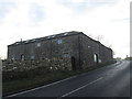
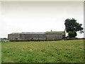
B6161 outside Briscoerigg Farm
Farm beside the B6161 between Leathley and Beckwithshaw
Image: © Chris Heaton
Taken: 15 Aug 2012
0.00 miles
3
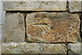
Cut Bench Mark, Briscoerigg Farm
Bench Mark Database: http://www.bench-marks.org.uk/bm34741
Image: © Mark Anderson
Taken: 27 Jun 2010
0.01 miles
4
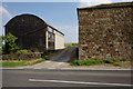
Entrance to Briscoerigg Farm
There is a cut bench mark on the corner of the building to the right of the entrance. A closer view can be seen here: Image
Image: © Mark Anderson
Taken: 27 Jun 2010
0.01 miles
5
Briscoerigg Farm
The farm seen from the pasture on the opposite side of the B6161
Image: © Chris Heaton
Taken: 15 Aug 2012
0.02 miles
7
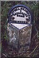
Old Milestone, on the B6161, Otley Road
Near Briscoerigg Farm. Located on the East side of road, on verge south of farm and bend. Stone post (plate lost), WR Casting design, 19th century.
Inscription reads: (BRADFORD / 15 MILES) // (KILLING / HALL / 5½ MILES) // (DUDLEY HILL KILLINGHALL / & / HARROGATE / ROAD / STAINBURN)
Grade II listed by Historic England.
Milestone Society National ID: YN_BFKH15
Image: © Christine Minto
Taken: 28 Dec 2005
0.03 miles
8
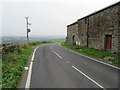
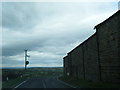
Briscoerigg road junction
At this point a minor road reaches a junction with the B6161, a busy route that takes traffic from the Harrogate area towards Pool in Wharfedale. The road was built as a turnpike from the edge of Bradford to Killinghall, probably before the days when Harrogate became known as an important spa town.
Image: © Gordon Hatton
Taken: 19 Jul 2023
0.03 miles
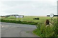
9
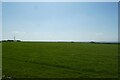
Field and communications mast
Fields beside the road between Beckwithshaw and Leathley.
Image: © DS Pugh
Taken: 3 Jun 2023
0.11 miles
10
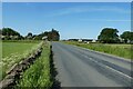
Road near Highfield Farm
The road between Beckwithshaw and Leathley.
Image: © DS Pugh
Taken: 3 Jun 2023
0.12 miles