IMAGES TAKEN NEAR TO
Crimple Meadows, HARROGATE, HG3 1EL
Introduction
This page details the photographs taken nearby to Crimple Meadows, HG3 1EL by members of the Geograph project.
The Geograph project started in 2005 with the aim of publishing, organising and preserving representative images for every square kilometre of Great Britain, Ireland and the Isle of Man.

There are currently over 7.5m images from over14,400 individuals and you can help contribute to the project by visiting https://www.geograph.org.uk
Image Map (Loading...)


Getting Data...Please wait
Leaflet Map data © OpenStreetMap
Images are licensed for reuse under creativecommons.org/licenses/by-sa/2.0
Notes
- Clicking on the map will re-center to the selected point.
- The higher the marker number, the further away the image location is from the centre of the postcode.
Image Listing (160 Images Found)
Images are licensed for reuse under creativecommons.org/licenses/by-sa/2.0
Image
Details
Distance
7
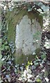
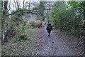
Old Boundary Marker
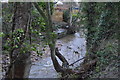
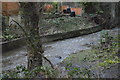
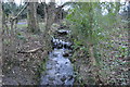
Knaresborough Forest Enclosure Boundary Marker in a ditch between the mill pond and the cricket field in Pannal, where the Buttersyke meets the Crimple. Pannal and Burn Bridge parish. Inscribed 1 / K · F / 1767. Erected to delineate the Forest of Knaresborough preparatory to enclosure. Grade II Listed https://historicengland.org.uk/listing/the-list/list-entry/1263920.
Milestone Society National ID: YW_KF01pb
Image: © D Garside
Taken: 2 Sep 2017
0.10 miles