IMAGES TAKEN NEAR TO
Park Terrace, HARROGATE, HG3 1BW
Introduction
This page details the photographs taken nearby to Park Terrace, HG3 1BW by members of the Geograph project.
The Geograph project started in 2005 with the aim of publishing, organising and preserving representative images for every square kilometre of Great Britain, Ireland and the Isle of Man.

There are currently over 7.5m images from over14,400 individuals and you can help contribute to the project by visiting https://www.geograph.org.uk
Image Map (Loading...)


Getting Data...Please wait
Leaflet Map data © OpenStreetMap
Images are licensed for reuse under creativecommons.org/licenses/by-sa/2.0
Notes
- Clicking on the map will re-center to the selected point.
- The higher the marker number, the further away the image location is from the centre of the postcode.
Image Listing (64 Images Found)
Images are licensed for reuse under creativecommons.org/licenses/by-sa/2.0
Image
Details
Distance
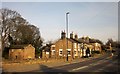
2
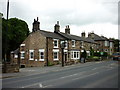
The Railway Inn, Spofforth
A Sam Smith's pub.
Image: © Ian S
Taken: 14 May 2011
0.01 miles
3
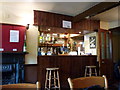
Inside the Railway Inn, a Sam Smith's pub, Spofforth
Image: © Ian S
Taken: 14 May 2011
0.01 miles
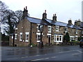
4
The Railway Inn, Spofforth
A Sam Smiths public house.
Image: © Ian S
Taken: 25 Nov 2013
0.01 miles
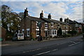
5
Railway Inn, Spofforth
The inn is shown from a similar angle in some of the photos at http://www.geograph.org.uk/search.php?i=57011643 but I couldn't resist adding this one, taken on a glorious Easter Bank Holiday Monday. The road is the A661.
Image: © Derek Harper
Taken: 6 Apr 2015
0.01 miles
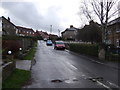
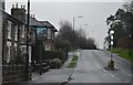
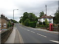
8
Park Road
Looking towards The Railway Inn in Spofforth.
Image: © DS Pugh
Taken: 2 Jun 2023
0.04 miles
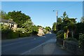
9
Spofforth - A661
The A661 running through Spofforth. The bridge where the photo was taken used to cross over the Harrogate to Wetherby railway, hence the Pub on the left is called the Railway Inn. The trackbed from here to Wetherby is now a sustrans cycle route known as the Harland Way.
Image: © DS Pugh
Taken: 20 Aug 2006
0.04 miles
10
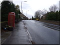
High Street (A661), Spofforth
K6 telephone box on the left.
Image: © JThomas
Taken: 7 Dec 2013
0.05 miles