IMAGES TAKEN NEAR TO
High Street, HARROGATE, HG3 1BQ
Introduction
This page details the photographs taken nearby to High Street, HG3 1BQ by members of the Geograph project.
The Geograph project started in 2005 with the aim of publishing, organising and preserving representative images for every square kilometre of Great Britain, Ireland and the Isle of Man.

There are currently over 7.5m images from over14,400 individuals and you can help contribute to the project by visiting https://www.geograph.org.uk
Image Map
Images are licensed for reuse under creativecommons.org/licenses/by-sa/2.0
Notes
- Clicking on the map will re-center to the selected point.
- The higher the marker number, the further away the image location is from the centre of the postcode.
Image Listing (215 Images Found)
Images are licensed for reuse under creativecommons.org/licenses/by-sa/2.0
Image
Details
Distance
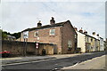
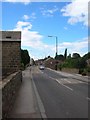
3
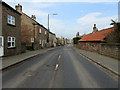
High Street, Spofforth
Heading north west into Spofforth on the A661 from Wetherby.
Image: © Chris Heaton
Taken: 14 Mar 2014
0.01 miles
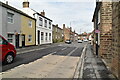
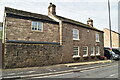
5
High Street, Spofforth
Terraced buildings on the north side of the A661 approaching the right-angled bend in the main road.
Image: © Derek Harper
Taken: 6 Apr 2015
0.02 miles
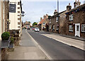
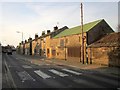
7
Spofforth
The village of Spofforth, situated half way between Harrogate and Wetherby on the A661.
Image: © DS Pugh
Taken: 7 Jul 2007
0.02 miles