IMAGES TAKEN NEAR TO
Church Lane, HARROGATE, HG3 1AF
Introduction
This page details the photographs taken nearby to Church Lane, HG3 1AF by members of the Geograph project.
The Geograph project started in 2005 with the aim of publishing, organising and preserving representative images for every square kilometre of Great Britain, Ireland and the Isle of Man.

There are currently over 7.5m images from over14,400 individuals and you can help contribute to the project by visiting https://www.geograph.org.uk
Image Map
Images are licensed for reuse under creativecommons.org/licenses/by-sa/2.0
Notes
- Clicking on the map will re-center to the selected point.
- The higher the marker number, the further away the image location is from the centre of the postcode.
Image Listing (237 Images Found)
Images are licensed for reuse under creativecommons.org/licenses/by-sa/2.0
Image
Details
Distance
1
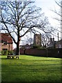
Village green and church
Behind the main street of Spofforth is this triangular green with a view to the tower of All Saints church.
Image: © Gordon Hatton
Taken: 9 Dec 2009
0.01 miles
2

Holy Week display, Church Lane, Spofforth
The grass verge has been used to display the story of Jesus' last week leading to his crucifixion. I met the vicar who was about to erect the last scene for Easter day.
Image: © Stephen Craven
Taken: 3 Apr 2021
0.01 miles
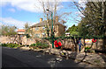
3
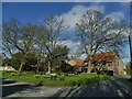
Junction of Church Lane and Church Hill, Spofforth
A small village green.
Image: © Stephen Craven
Taken: 3 Apr 2021
0.02 miles
4
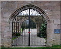
Entrance to the Old Rectory, Spofforth
Locked and barred with impressive metal gates - this entrance can be found on Church Lane in Spofforth
Image: © Chris Heaton
Taken: 14 Mar 2014
0.02 miles
5
Archway to the Old Rectory, Church Lane, Spofforth
The structure is grade II listed (entry 1149980) where the likelihood or otherwise of the arch being either ancient or in its original location are discussed. The gates themselves are modern, and the present rectory is on the other side of the road.
Image: © Stephen Craven
Taken: 3 Apr 2021
0.02 miles
6
Church Lane, Spofforth
A close up of Spofforth Mounting Stone (under the blue plaque) can be seen in Image
Image: © habiloid
Taken: 2 Apr 2021
0.02 miles
7
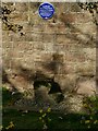
Mounting block, Church Lane, Spofforth
The stone block is listed grade II (entry 1393596) as "a good example of a once common piece of street furniture, a reminder of the former importance of horse transport" and dates from some time before 1840.
Image: © Stephen Craven
Taken: 3 Apr 2021
0.02 miles
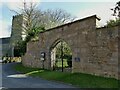
8
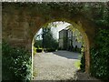
Old Rectory with inner arch, Church Lane, Spofforth
The former rectory itself is grade II listed (entry 1149979) and mainly late 18th century with but with 14th century remains. The archway seen here (through the gates in the outer arch) is separately listed (entry 1149980) and was moved here in 1982 from an old stables building. The present rectory is on the other side of the road. See Image for a view of both arches.
Image: © Stephen Craven
Taken: 3 Apr 2021
0.02 miles
9
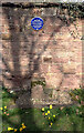
Spofforth Mounting Stone
The mounting stone (used to assist mounting horses) can be seen in context in Image
Image: © habiloid
Taken: 2 Apr 2021
0.03 miles
10
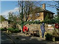
War memorial bench, Church Lane, Spofforth
The bench is accompanied by three large poppies and a 'silent soldier' figure.
Image: © Stephen Craven
Taken: 3 Apr 2021
0.03 miles