IMAGES TAKEN NEAR TO
Redfearn Mews, HARROGATE, HG2 9QL
Introduction
This page details the photographs taken nearby to Redfearn Mews, HG2 9QL by members of the Geograph project.
The Geograph project started in 2005 with the aim of publishing, organising and preserving representative images for every square kilometre of Great Britain, Ireland and the Isle of Man.

There are currently over 7.5m images from over14,400 individuals and you can help contribute to the project by visiting https://www.geograph.org.uk
Image Map
Images are licensed for reuse under creativecommons.org/licenses/by-sa/2.0
Notes
- Clicking on the map will re-center to the selected point.
- The higher the marker number, the further away the image location is from the centre of the postcode.
Image Listing (71 Images Found)
Images are licensed for reuse under creativecommons.org/licenses/by-sa/2.0
Image
Details
Distance
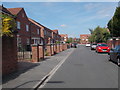
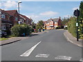
3
Hutton Gate - looking towards Woods Court
Image: © Betty Longbottom
Taken: 16 Aug 2016
0.06 miles
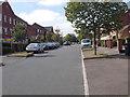
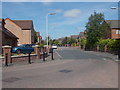
4
Along St. George's Walk
Looking along St. George's Walk towards the mini roundabout with St. George's Road.
Image: © DS Pugh
Taken: 24 Dec 2021
0.08 miles
5
St George's Walk - St George's Road
Image: © Betty Longbottom
Taken: 16 Aug 2016
0.08 miles
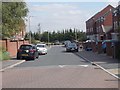
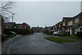
8
Rhodes Drive
Looking along Rhodes Drive on a December afternoon.
Image: © DS Pugh
Taken: 23 Dec 2020
0.09 miles
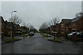
9
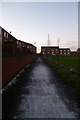
Path to Verity Walk
Leading from Rhodes Drive.
Image: © DS Pugh
Taken: 30 Dec 2014
0.09 miles
10
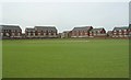
Harrogate Cricket Club - Leadhall Drive
Image: © Betty Longbottom
Taken: 24 Jun 2008
0.10 miles