IMAGES TAKEN NEAR TO
Rossett Park Road, HARROGATE, HG2 9NP
Introduction
This page details the photographs taken nearby to Rossett Park Road, HG2 9NP by members of the Geograph project.
The Geograph project started in 2005 with the aim of publishing, organising and preserving representative images for every square kilometre of Great Britain, Ireland and the Isle of Man.

There are currently over 7.5m images from over14,400 individuals and you can help contribute to the project by visiting https://www.geograph.org.uk
Image Map
Images are licensed for reuse under creativecommons.org/licenses/by-sa/2.0
Notes
- Clicking on the map will re-center to the selected point.
- The higher the marker number, the further away the image location is from the centre of the postcode.
Image Listing (65 Images Found)
Images are licensed for reuse under creativecommons.org/licenses/by-sa/2.0
Image
Details
Distance
1
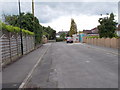
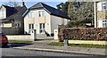
Rossett Crescent - Rossett Park Road
Image: © Betty Longbottom
Taken: 21 Jun 2016
0.04 miles
2
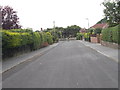
Rossett Crescent - Rossett Park Road
Image: © Betty Longbottom
Taken: 21 Jun 2016
0.04 miles
3
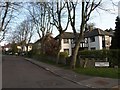
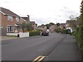
Rossett Park Road
A tree-lined road of detached houses leading off Leadhall Lane.
Image: © Derek Harper
Taken: 13 Apr 2009
0.05 miles
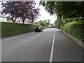
5
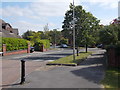
Looking NE along Leadhall Lane from outside #57
There is a boundary stone with an Ordnance Survey benchmark Image on its top on the verge
Image: © Roger Templeman
Taken: 14 Feb 2023
0.08 miles
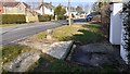
9
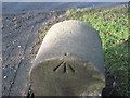
Ordnance Survey Rivet
This can be found in Leadhall Lane on a boundary stone near house number 57.
Image: © Peter Wood
Taken: 22 Jan 2012
0.09 miles
10
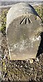
Benchmark on boundary stone on verge outside #57 Leadhall Lane
Ordnance Survey rivet benchmark levelled at 143.796m above Newlyn Datum verified 1968. The rivet is missing.
The stone has Milestone Society National ID: YW_HARR03bm and probably marked the Pannal / Harrogate boundary
Image: © Roger Templeman
Taken: 14 Feb 2023
0.09 miles