IMAGES TAKEN NEAR TO
Leadhall Lane, HARROGATE, HG2 9NE
Introduction
This page details the photographs taken nearby to Leadhall Lane, HG2 9NE by members of the Geograph project.
The Geograph project started in 2005 with the aim of publishing, organising and preserving representative images for every square kilometre of Great Britain, Ireland and the Isle of Man.

There are currently over 7.5m images from over14,400 individuals and you can help contribute to the project by visiting https://www.geograph.org.uk
Image Map
Images are licensed for reuse under creativecommons.org/licenses/by-sa/2.0
Notes
- Clicking on the map will re-center to the selected point.
- The higher the marker number, the further away the image location is from the centre of the postcode.
Image Listing (141 Images Found)
Images are licensed for reuse under creativecommons.org/licenses/by-sa/2.0
Image
Details
Distance
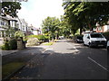
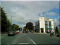
1
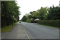
Leadhall Lane
Looking along Leadhall Lane in Harrogate near Leadhall drive.
Image: © DS Pugh
Taken: 3 Sep 2018
0.04 miles
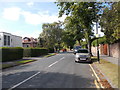
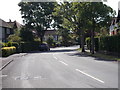
2
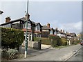
Leadhill Lane
Houses on Leadhill Lane, Harrogate
Image: © Andrew Abbott
Taken: 29 Feb 2020
0.04 miles
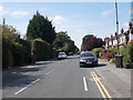
3
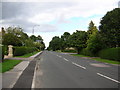
Leadhall Lane
Running between Leeds Road and Rossett. This road at one time was famous for being always under repair and was the road in the country spending the most days per year being dug up.
Image: © DS Pugh
Taken: 21 Aug 2006
0.05 miles
4
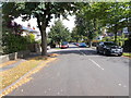
Vernon Road - viewed from Kenilworth Avenue
Image: © Betty Longbottom
Taken: 16 Aug 2016
0.06 miles
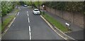
10
Leadhall Crescent - Leadhall Lane
Image: © Betty Longbottom
Taken: 16 Aug 2016
0.08 miles